Tehuetlán geodata
Tehuetlán (Hidalgo) is a populated place; located in Mexico in America/Mexico_City (GMT-6) time zone. With population of 3,024 people, there are 2972 cities with bigger population in this country. Compared to other cities in Mexico, 77.2% of cities are located further ↓South; 57.1% of cities are located further ←West and 72.1% of cities have higher elevation than Tehuetlán. Note1


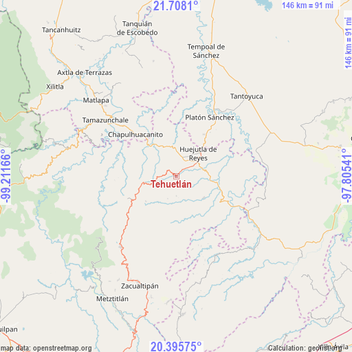
Tehuetlán GPS coordinates[2]
21° 3' 12.132" North, 98° 30' 30.708" West
| Map corner | latitude | longitude |
|---|---|---|
| Upper-left | 21.7081°, | -99.21166° |
| Center: | 21.05337°, | -98.50853° |
| Lower-right: | 20.39575°, | -97.80541° |
| Map W x H: | 145.9×145.9 km | = 90.7×90.7mi |
| max Lat: | 32.7° ⇑22.8% North |
| Tehuetlán: | 21.05337° |
| min Lat: | ⇓77.2% South 14.53588° |
| min Long | Tehuetlán | max Long |
| -117.105° | -98.50853° | -86.73105° |
| W 57.1%⇐ | ⇒42.9% E |
Elevation
Elevation of Tehuetlán is 324 m = 1063 ft, and this is 929.7 m = 3050 ft below average elevation for this country.
| Max E: |
3497 m = 11473 ft | 72.1% |
| Avg. | 1253.7 m = 4113 ft | |
| Tehuetlán | 324 m = 1063 ft | |
Min E: |
-1 m = -3 ft | 27.9% |
See also: Mexico elevation on elevation.city.
Geographical zone
Tehuetlán is located in North Torrid zone (between Equator and Tropic of Cancer). Distance of this Northern Tropic circle is 265 km =164.7 mi to North.| Distance of | km | miles | from Tehuetlán |
|---|---|---|---|
| North Pole | 7666.1 | 4763.5 | to North |
| Arctic Circle | 5060.3 | 3144.3 | to North |
| Tropic Cancer | 265 | 164.7 | to North |
| Equator | 2340.9 | 1454.6 | to South |


Nearby cities:
15 places around Tehuetlán: (largest is in red/bold)
• Acatipa
7.3 km =4.5 mi,  267°
267°
• Acoapa
7.9 km =4.9 mi,  16°
16°
• Acuatempa
4.3 km =2.7 mi,  63°
63°
• Aquixcuatitla
7.2 km =4.5 mi,  31°
31°
• Axcaco
3.8 km =2.4 mi,  299°
299°
• Chatipán
4.2 km =2.6 mi,  207°
207°
• Coamila
6.3 km =3.9 mi,  10°
10°
• Ixcatlán
4.1 km =2.5 mi,  318°
318°
• Ixcatépec
5.4 km =3.4 mi,  348°
348°
• Machetla
1.6 km =1 mi,  65°
65°
• Pahuatlán
3.8 km =2.4 mi, 61°
• Peyula
6.8 km =4.2 mi,  257°
257°
• Pilchatipa
4.6 km =2.9 mi,  118°
118°
• San Francisco
4.5 km =2.8 mi,  150°
150°
• Xiquila
7.3 km =4.5 mi, 67°
Sources, notices
• [Note1] Compared only with cities in Mexico existing in our database
• [Src1] Map data: © OpenStreetMap contributors (CC-BY-SA)
• [Src2] Other city data from geonames.org with taken over terms of usage.
• [Src3] Geographical zone / Annual Mean Temperature by Robert A. Rohde @ Wikipedia
