Tecomate geodata
Tecomate (Veracruz) is a populated place; located in Mexico in America/Mexico_City (GMT-6) time zone. With population of 619 people, there are 13941 cities with bigger population in this country. Compared to other cities in Mexico, 72.9% of cities are located further ↓South; 68.9% of cities are located further ←West and 85% of cities have higher elevation than Tecomate. Note1


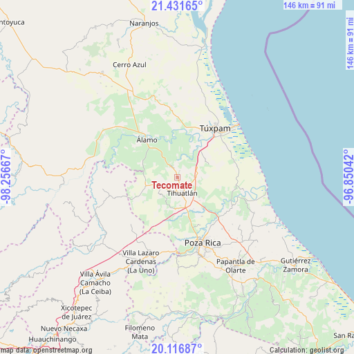
Tecomate GPS coordinates[2]
20° 46' 32.484" North, 97° 33' 12.744" West
| Map corner | latitude | longitude |
|---|---|---|
| Upper-left | 21.43165°, | -98.25667° |
| Center: | 20.77569°, | -97.55354° |
| Lower-right: | 20.11687°, | -96.85042° |
| Map W x H: | 146.2×146.2 km | = 90.8×90.8mi |
| max Lat: | 32.7° ⇑27.1% North |
| Tecomate: | 20.77569° |
| min Lat: | ⇓72.9% South 14.53588° |
| min Long | Tecomate | max Long |
| -117.105° | -97.55354° | -86.73105° |
| W 68.9%⇐ | ⇒31.1% E |
Elevation
Elevation of Tecomate is 44 m = 144 ft, and this is 1209.7 m = 3969 ft below average elevation for this country.
| Max E: |
3497 m = 11473 ft | 85% |
| Avg. | 1253.7 m = 4113 ft | |
| Tecomate | 44 m = 144 ft | |
Min E: |
-1 m = -3 ft | 15% |
See also: Mexico elevation on elevation.city.
Geographical zone
Tecomate is located in North Torrid zone (between Equator and Tropic of Cancer). Distance of this Northern Tropic circle is 295.9 km =183.9 mi to North.| Distance of | km | miles | from Tecomate |
|---|---|---|---|
| North Pole | 7697 | 4782.7 | to North |
| Arctic Circle | 5091.1 | 3163.5 | to North |
| Tropic Cancer | 295.9 | 183.9 | to North |
| Equator | 2310 | 1435.4 | to South |


Nearby cities:
15 places around Tecomate: (largest is in red/bold)
• Buenos Aires (San Isidro)
8.7 km =5.4 mi,  325°
325°
• Castillo de Teayo
8.5 km =5.3 mi,  249°
249°
• Cañada Rica
9.6 km =6 mi,  56°
56°
• Cerro Dulce
9.9 km =6.2 mi,  321°
321°
• Chichimantla Segundo
11.9 km =7.4 mi,  132°
132°
• Citlaltépetl
11.3 km =7 mi, 330°
• El Bejucal
11.4 km =7.1 mi,  286°
286°
• El Oriente
6.1 km =3.8 mi,  122°
122°
• El Terrero
2.9 km =1.8 mi,  18°
18°
• Francisco Villa
2 km =1.2 mi,  336°
336°
• Jiliapa Segundo
11 km =6.8 mi,  206°
206°
• La Granadilla
6.7 km =4.2 mi,  345°
345°
• Lima Vieja
8.2 km =5.1 mi,  279°
279°
• Raudal Nuevo
12.1 km =7.5 mi, 345°
• Tihuatlan
7.1 km =4.4 mi,  162°
162°
Sources, notices
• [Note1] Compared only with cities in Mexico existing in our database
• [Src1] Map data: © OpenStreetMap contributors (CC-BY-SA)
• [Src2] Other city data from geonames.org with taken over terms of usage.
• [Src3] Geographical zone / Annual Mean Temperature by Robert A. Rohde @ Wikipedia
