Jiliapa Segundo geodata
Jiliapa Segundo (Veracruz) is a populated place; located in Mexico in America/Mexico_City (GMT-6) time zone. With population of 641 people, there are 13506 cities with bigger population in this country. Compared to other cities in Mexico, 71.4% of cities are located further ↓South; 68.4% of cities are located further ←West and 79.8% of cities have higher elevation than Jiliapa Segundo. Note1


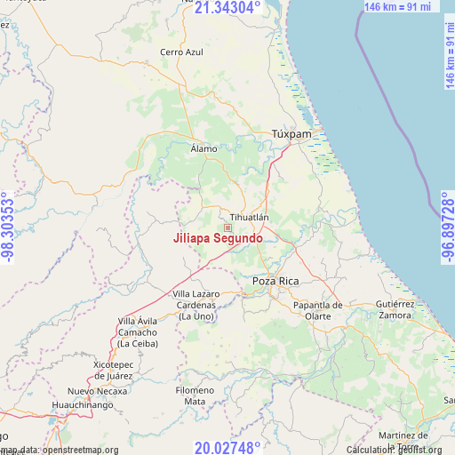
Jiliapa Segundo GPS coordinates[2]
20° 41' 12.084" North, 97° 36' 1.44" West
| Map corner | latitude | longitude |
|---|---|---|
| Upper-left | 21.34304°, | -98.30353° |
| Center: | 20.68669°, | -97.6004° |
| Lower-right: | 20.02748°, | -96.89728° |
| Map W x H: | 146.3×146.3 km | = 90.9×90.9mi |
| max Lat: | 32.7° ⇑28.6% North |
| Jiliapa Segundo: | 20.68669° |
| min Lat: | ⇓71.4% South 14.53588° |
| min Long | Jiliapa Segundo | max Long |
| -117.105° | -97.6004° | -86.73105° |
| W 68.4%⇐ | ⇒31.6% E |
Elevation
Elevation of Jiliapa Segundo is 97 m = 318 ft, and this is 1156.7 m = 3795 ft below average elevation for this country.
| Max E: |
3497 m = 11473 ft | 79.8% |
| Avg. | 1253.7 m = 4113 ft | |
| Jiliapa Segundo | 97 m = 318 ft | |
Min E: |
-1 m = -3 ft | 20.2% |
See also: Mexico elevation on elevation.city.
Geographical zone
Jiliapa Segundo is located in North Torrid zone (between Equator and Tropic of Cancer). Distance of this Northern Tropic circle is 305.8 km =190 mi to North.| Distance of | km | miles | from Jiliapa Segundo |
|---|---|---|---|
| North Pole | 7706.9 | 4788.8 | to North |
| Arctic Circle | 5101 | 3169.6 | to North |
| Tropic Cancer | 305.8 | 190 | to North |
| Equator | 2300.1 | 1429.2 | to South |


Nearby cities:
15 places around Jiliapa Segundo: (largest is in red/bold)
• Castillo de Teayo
7.6 km =4.7 mi,  335°
335°
• El Copal
8.5 km =5.3 mi,  155°
155°
• El Oriente
12 km =7.5 mi,  56°
56°
• Enrique Rodríguez Cano (Zapotalillo)
6.1 km =3.8 mi,  119°
119°
• Francisco Villa
12.4 km =7.7 mi,  19°
19°
• Huizotate
13.3 km =8.3 mi,  145°
145°
• La Defensa
12.4 km =7.7 mi,  260°
260°
• La Guadalupe
4.3 km =2.7 mi,  287°
287°
• La Isla (Kilómetro 10)
13.5 km =8.4 mi,  130°
130°
• Lima Vieja
11.7 km =7.3 mi, 344°
• Nuevo Progreso
12.3 km =7.6 mi, 128°
• Poza Azul de los Reyes
11.6 km =7.2 mi,  230°
230°
• Teayo
10.4 km =6.5 mi,  307°
307°
• Tecomate
11 km =6.8 mi,  26°
26°
• Tihuatlan
7.6 km =4.7 mi,  66°
66°
Sources, notices
• [Note1] Compared only with cities in Mexico existing in our database
• [Src1] Map data: © OpenStreetMap contributors (CC-BY-SA)
• [Src2] Other city data from geonames.org with taken over terms of usage.
• [Src3] Geographical zone / Annual Mean Temperature by Robert A. Rohde @ Wikipedia
