La Granadilla geodata
La Granadilla (Veracruz) is a populated place; located in Mexico in America/Mexico_City (GMT-6) time zone. With population of 522 people, there are 16162 cities with bigger population in this country. Compared to other cities in Mexico, 73.8% of cities are located further ↓South; 68.8% of cities are located further ←West and 85.7% of cities have higher elevation than La Granadilla. Note1


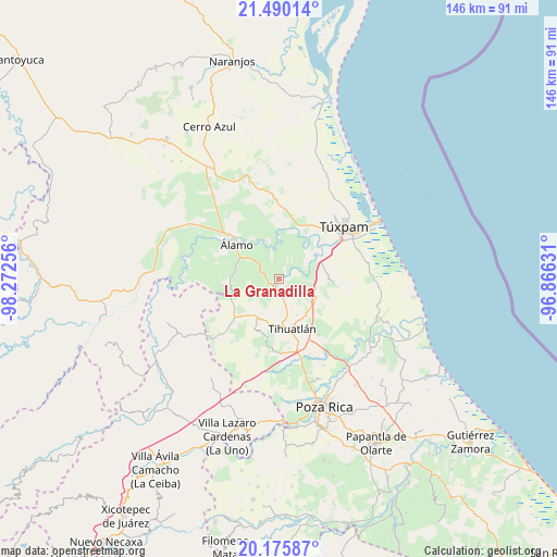
La Granadilla GPS coordinates[2]
20° 50' 3.984" North, 97° 34' 9.948" West
| Map corner | latitude | longitude |
|---|---|---|
| Upper-left | 21.49014°, | -98.27256° |
| Center: | 20.83444°, | -97.56943° |
| Lower-right: | 20.17587°, | -96.86631° |
| Map W x H: | 146.1×146.1 km | = 90.8×90.8mi |
| max Lat: | 32.7° ⇑26.2% North |
| La Granadilla: | 20.83444° |
| min Lat: | ⇓73.8% South 14.53588° |
| min Long | La Granadilla | max Long |
| -117.105° | -97.56943° | -86.73105° |
| W 68.8%⇐ | ⇒31.2% E |
Elevation
Elevation of La Granadilla is 40 m = 131 ft, and this is 1213.7 m = 3982 ft below average elevation for this country.
| Max E: |
3497 m = 11473 ft | 85.7% |
| Avg. | 1253.7 m = 4113 ft | |
| La Granadilla | 40 m = 131 ft | |
Min E: |
-1 m = -3 ft | 14.3% |
See also: Mexico elevation on elevation.city.
Geographical zone
La Granadilla is located in North Torrid zone (between Equator and Tropic of Cancer). Distance of this Northern Tropic circle is 289.3 km =179.8 mi to North.| Distance of | km | miles | from La Granadilla |
|---|---|---|---|
| North Pole | 7690.5 | 4778.7 | to North |
| Arctic Circle | 5084.6 | 3159.4 | to North |
| Tropic Cancer | 289.3 | 179.8 | to North |
| Equator | 2316.6 | 1439.5 | to South |


Nearby cities:
15 places around La Granadilla: (largest is in red/bold)
• Buenos Aires (San Isidro)
3.4 km =2.1 mi,  281°
281°
• Cañada Rica
9.7 km =6 mi,  97°
97°
• Cerro Dulce
4.7 km =2.9 mi, 284°
• Citlaltépetl
5.2 km =3.2 mi,  309°
309°
• Doctor Montes de Oca
11.2 km =7 mi,  7°
7°
• El Bejucal
9.8 km =6.1 mi,  250°
250°
• El Terrero
4.6 km =2.9 mi,  145°
145°
• Estero del Ídolo
11.1 km =6.9 mi,  303°
303°
• Francisco Villa
4.8 km =3 mi,  169°
169°
• Hidalgo Amajac
10 km =6.2 mi,  321°
321°
• Kilómetro Treinta y Tres (Paso Real)
8 km =5 mi,  341°
341°
• La Reforma
9.6 km =6 mi,  291°
291°
• Lima Vieja
8.3 km =5.2 mi,  231°
231°
• Raudal Nuevo
5.3 km =3.3 mi,  345°
345°
• Tecomate
6.7 km =4.2 mi, 165°
Sources, notices
• [Note1] Compared only with cities in Mexico existing in our database
• [Src1] Map data: © OpenStreetMap contributors (CC-BY-SA)
• [Src2] Other city data from geonames.org with taken over terms of usage.
• [Src3] Geographical zone / Annual Mean Temperature by Robert A. Rohde @ Wikipedia
