Chichimantla Segundo geodata
Chichimantla Segundo (Veracruz) is a populated place; located in Mexico in America/Mexico_City (GMT-6) time zone. With population of 882 people, there are 9904 cities with bigger population in this country. Compared to other cities in Mexico, 71.7% of cities are located further ↓South; 69.9% of cities are located further ←West and 83.4% of cities have higher elevation than Chichimantla Segundo. Note1


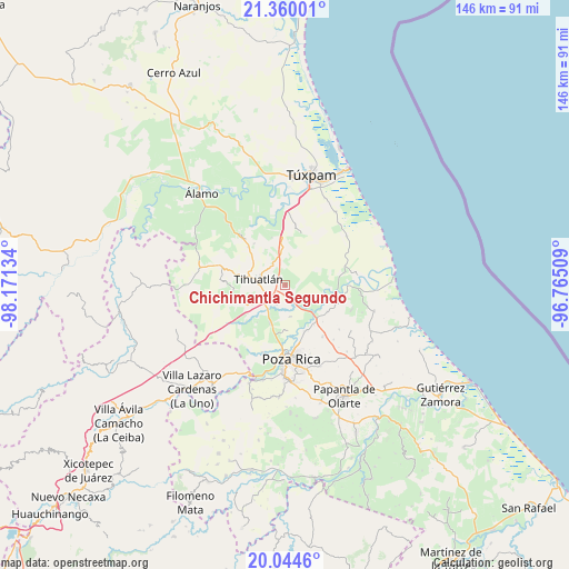
Chichimantla Segundo GPS coordinates[2]
20° 42' 13.428" North, 97° 28' 5.556" West
| Map corner | latitude | longitude |
|---|---|---|
| Upper-left | 21.36001°, | -98.17134° |
| Center: | 20.70373°, | -97.46821° |
| Lower-right: | 20.0446°, | -96.76509° |
| Map W x H: | 146.3×146.3 km | = 90.9×90.9mi |
| max Lat: | 32.7° ⇑28.3% North |
| Chichimantla Segundo: | 20.70373° |
| min Lat: | ⇓71.7% South 14.53588° |
| min Long | Chichimantla Se | max Long |
| -117.105° | -97.46821° | -86.73105° |
| W 69.9%⇐ | ⇒30.1% E |
Elevation
Elevation of Chichimantla Segundo is 57 m = 187 ft, and this is 1196.7 m = 3926 ft below average elevation for this country.
| Max E: |
3497 m = 11473 ft | 83.4% |
| Avg. | 1253.7 m = 4113 ft | |
| Chichimantla Segundo | 57 m = 187 ft | |
Min E: |
-1 m = -3 ft | 16.6% |
See also: Mexico elevation on elevation.city.
Geographical zone
Chichimantla Segundo is located in North Torrid zone (between Equator and Tropic of Cancer). Distance of this Northern Tropic circle is 303.9 km =188.8 mi to North.| Distance of | km | miles | from Chichimantla Segundo |
|---|---|---|---|
| North Pole | 7705 | 4787.7 | to North |
| Arctic Circle | 5099.1 | 3168.4 | to North |
| Tropic Cancer | 303.9 | 188.8 | to North |
| Equator | 2302 | 1430.4 | to South |


Nearby cities:
15 places around Chichimantla Segundo: (largest is in red/bold)
• Acontitla
9 km =5.6 mi,  105°
105°
• El Oriente
6.1 km =3.8 mi,  321°
321°
• El Palmar
11.6 km =7.2 mi,  159°
159°
• El Águila
8.2 km =5.1 mi,  171°
171°
• Enrique Rodríguez Cano (Zapotalillo)
9.7 km =6 mi,  239°
239°
• La Concepción
9.3 km =5.8 mi,  131°
131°
• La Isla (Kilómetro 10)
11.2 km =7 mi,  197°
197°
• La Isla Km 10
11.3 km =7 mi, 196°
• Laja del Tubo
11.3 km =7 mi,  51°
51°
• Nuevo Progreso
10.4 km =6.5 mi, 203°
• Nuevo Tejamanil
8.2 km =5.1 mi,  74°
74°
• Paso del Pital
9.9 km =6.2 mi,  145°
145°
• Tecomate
11.9 km =7.4 mi,  312°
312°
• Tihuatlan
6.9 km =4.3 mi,  280°
280°
• Úrsulo Galván
11.6 km =7.2 mi, 164°
Sources, notices
• [Note1] Compared only with cities in Mexico existing in our database
• [Src1] Map data: © OpenStreetMap contributors (CC-BY-SA)
• [Src2] Other city data from geonames.org with taken over terms of usage.
• [Src3] Geographical zone / Annual Mean Temperature by Robert A. Rohde @ Wikipedia
