Tapachula geodata
Tapachula (Chiapas) is a seat of a second-order administrative division; located in Mexico in America/Mexico_City (GMT-6) time zone. With population of 202,672 people, there are 88 cities with bigger population in this country. Compared to other cities in Mexico, 99.7% of cities are located further ↑North; 93.7% of cities are located further ←West and 76.4% of cities have higher elevation than Tapachula. Note1


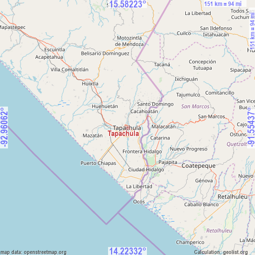
Tapachula GPS coordinates[2]
14° 54' 13.86" North, 92° 15' 26.964" West
| Map corner | latitude | longitude |
|---|---|---|
| Upper-left | 15.58223°, | -92.96062° |
| Center: | 14.90385°, | -92.25749° |
| Lower-right: | 14.22332°, | -91.55437° |
| Map W x H: | 151.1×151.1 km | = 93.9×93.9mi |
| max Lat: | 32.7° ⇑99.7% North |
| Tapachula: | 14.90385° |
| min Lat: | ⇓0.3% South 14.53588° |
| min Long | Tapachula | max Long |
| -117.105° | -92.25749° | -86.73105° |
| W 93.7%⇐ | ⇒6.3% E |
Elevation
Elevation of Tapachula is 170 m = 558 ft, and this is 1083.7 m = 3555 ft below average elevation for this country.
| Max E: |
3497 m = 11473 ft | 76.4% |
| Avg. | 1253.7 m = 4113 ft | |
| Tapachula | 170 m = 558 ft | |
Min E: |
-1 m = -3 ft | 23.6% |
See also: Tapachula elevation on elevation.city.
Geographical zone
Tapachula is located in North Torrid zone (between Equator and Tropic of Cancer). Distance of this Northern Tropic circle is 948.8 km =589.6 mi to North.| Distance of | km | miles | from Tapachula |
|---|---|---|---|
| North Pole | 8349.9 | 5188.4 | to North |
| Arctic Circle | 5744 | 3569.2 | to North |
| Tropic Cancer | 948.8 | 589.6 | to North |
| Equator | 1657.2 | 1029.7 | to South |


Nearby cities:
15 places around Tapachula: (largest is in red/bold)
• Cebadilla 1ra. Sección
5.1 km =3.2 mi,  208°
208°
• El Sacrificio
4.7 km =2.9 mi,  137°
137°
• La Joya
4.4 km =2.7 mi,  178°
178°
• Las Palmeras
4.5 km =2.8 mi, 205°
• Llano de la Lima
6 km =3.7 mi,  225°
225°
• Los Cafetales
6.3 km =3.9 mi, 229°
• Los Encinos
3.1 km =1.9 mi, 137°
• Los Palacios
5.2 km =3.2 mi, 180°
• Manga de Clavo
5.8 km =3.6 mi,  350°
350°
• Miguel Hidalgo
6.3 km =3.9 mi,  54°
54°
• Octavio Paz
5.2 km =3.2 mi,  187°
187°
• Pacayalito Dos
7.3 km =4.5 mi,  272°
272°
• Raymundo Enríquez
7.4 km =4.6 mi,  236°
236°
• Vida Mejor I
6.6 km =4.1 mi, 234°
• Viva México
7.4 km =4.6 mi,  275°
275°
In other languages:
- In Spanish: Tapachula, Tapachula de Córdova y Ordóñez
- In Russian: Тапачуле, Тапачула
- In Chinese: 塔帕丘拉
Sources, notices
• [Note1] Compared only with cities in Mexico existing in our database
• [Src1] Map data: © OpenStreetMap contributors (CC-BY-SA)
• [Src2] Other city data from geonames.org with taken over terms of usage.
• [Src3] Geographical zone / Annual Mean Temperature by Robert A. Rohde @ Wikipedia
