Los Encinos geodata
Los Encinos (Chiapas) is a populated place; located in Mexico in America/Mexico_City (GMT-6) time zone. With population of 681 people, there are 12756 cities with bigger population in this country. Compared to other cities in Mexico, 99.7% of cities are located further ↑North; 93.8% of cities are located further ←West and 77.1% of cities have higher elevation than Los Encinos. Note1


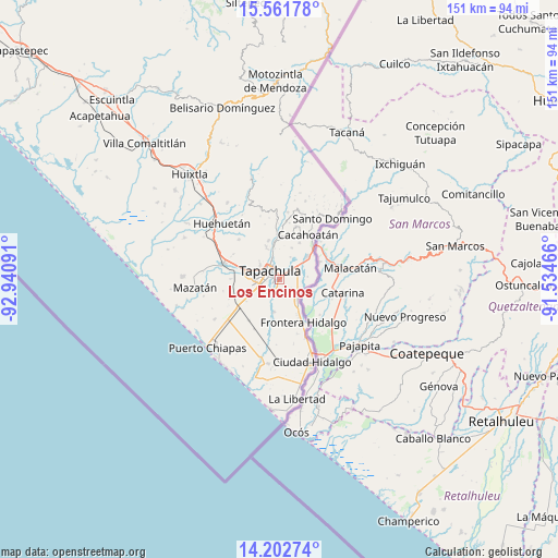
Los Encinos GPS coordinates[2]
14° 52' 59.988" North, 92° 14' 16.008" West
| Map corner | latitude | longitude |
|---|---|---|
| Upper-left | 15.56178°, | -92.94091° |
| Center: | 14.88333°, | -92.23778° |
| Lower-right: | 14.20274°, | -91.53466° |
| Map W x H: | 151.1×151.1 km | = 93.9×93.9mi |
| max Lat: | 32.7° ⇑99.7% North |
| Los Encinos: | 14.88333° |
| min Lat: | ⇓0.3% South 14.53588° |
| min Long | Los Encinos | max Long |
| -117.105° | -92.23778° | -86.73105° |
| W 93.8%⇐ | ⇒6.2% E |
Elevation
Elevation of Los Encinos is 149 m = 489 ft, and this is 1104.7 m = 3624 ft below average elevation for this country.
| Max E: |
3497 m = 11473 ft | 77.1% |
| Avg. | 1253.7 m = 4113 ft | |
| Los Encinos | 149 m = 489 ft | |
Min E: |
-1 m = -3 ft | 22.9% |
See also: Mexico elevation on elevation.city.
Geographical zone
Los Encinos is located in North Torrid zone (between Equator and Tropic of Cancer). Distance of this Northern Tropic circle is 951 km =590.9 mi to North.| Distance of | km | miles | from Los Encinos |
|---|---|---|---|
| North Pole | 8352.2 | 5189.8 | to North |
| Arctic Circle | 5746.3 | 3570.6 | to North |
| Tropic Cancer | 951 | 590.9 | to North |
| Equator | 1654.9 | 1028.3 | to South |


Nearby cities:
15 places around Los Encinos: (largest is in red/bold)
• 2da. Sección de Medio Monte
5.7 km =3.5 mi,  91°
91°
• Cebadilla 1ra. Sección
5 km =3.1 mi,  244°
244°
• El Sacrificio
1.6 km =1 mi,  137°
137°
• La Joya
2.9 km =1.8 mi,  222°
222°
• Las Palmeras
4.5 km =2.8 mi,  246°
246°
• Llano de la Lima
6.7 km =4.2 mi, 253°
• Los Cafetales
7.1 km =4.4 mi,  255°
255°
• Los Hules
6.3 km =3.9 mi,  126°
126°
• Los Palacios
3.6 km =2.2 mi, 217°
• Metapa
7.2 km =4.5 mi, 136°
• Miguel Hidalgo
6.7 km =4.2 mi,  26°
26°
• Octavio Paz
4 km =2.5 mi, 224°
• Omoa
5.6 km =3.5 mi,  174°
174°
• Tapachula
3.1 km =1.9 mi,  317°
317°
• Vicente Guerrero
4.5 km =2.8 mi, 131°
Sources, notices
• [Note1] Compared only with cities in Mexico existing in our database
• [Src1] Map data: © OpenStreetMap contributors (CC-BY-SA)
• [Src2] Other city data from geonames.org with taken over terms of usage.
• [Src3] Geographical zone / Annual Mean Temperature by Robert A. Rohde @ Wikipedia
