Manga de Clavo geodata
Manga de Clavo (Chiapas) is a populated place; located in Mexico in America/Mexico_City (GMT-6) time zone. With population of 625 people, there are 13838 cities with bigger population in this country. Compared to other cities in Mexico, 99.6% of cities are located further ↑North; 93.6% of cities are located further ←West and 73.6% of cities have higher elevation than Manga de Clavo. Note1


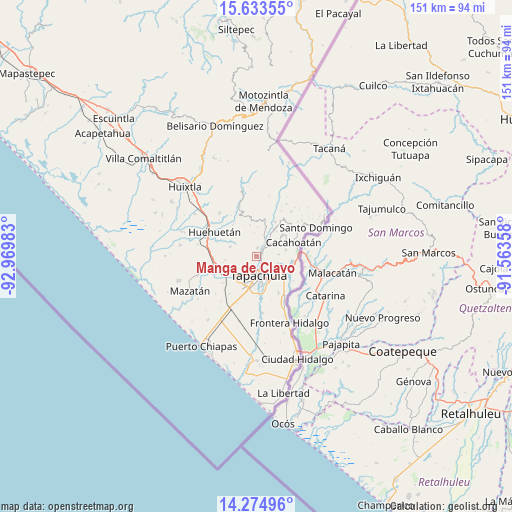
Manga de Clavo GPS coordinates[2]
14° 57' 19.188" North, 92° 16' 0.12" West
| Map corner | latitude | longitude |
|---|---|---|
| Upper-left | 15.63355°, | -92.96983° |
| Center: | 14.95533°, | -92.2667° |
| Lower-right: | 14.27496°, | -91.56358° |
| Map W x H: | 151.1×151.1 km | = 93.9×93.9mi |
| max Lat: | 32.7° ⇑99.6% North |
| Manga de Clavo: | 14.95533° |
| min Lat: | ⇓0.4% South 14.53588° |
| min Long | Manga de Clavo | max Long |
| -117.105° | -92.2667° | -86.73105° |
| W 93.6%⇐ | ⇒6.4% E |
Elevation
Elevation of Manga de Clavo is 269 m = 883 ft, and this is 984.7 m = 3231 ft below average elevation for this country.
| Max E: |
3497 m = 11473 ft | 73.6% |
| Avg. | 1253.7 m = 4113 ft | |
| Manga de Clavo | 269 m = 883 ft | |
Min E: |
-1 m = -3 ft | 26.4% |
See also: Mexico elevation on elevation.city.
Geographical zone
Manga de Clavo is located in North Torrid zone (between Equator and Tropic of Cancer). Distance of this Northern Tropic circle is 943 km =586 mi to North.| Distance of | km | miles | from Manga de Clavo |
|---|---|---|---|
| North Pole | 8344.2 | 5184.8 | to North |
| Arctic Circle | 5738.3 | 3565.6 | to North |
| Tropic Cancer | 943 | 586 | to North |
| Equator | 1662.9 | 1033.3 | to South |


Nearby cities:
15 places around Manga de Clavo: (largest is in red/bold)
• El Chaparrón
3.4 km =2.1 mi,  42°
42°
• El Triunfo
6.2 km =3.9 mi,  50°
50°
• Guadalupe
8.3 km =5.2 mi,  289°
289°
• Hermosillo
8.6 km =5.3 mi,  60°
60°
• Los Encinos
8.6 km =5.3 mi,  158°
158°
• Manuel Lazos
8.7 km =5.4 mi,  78°
78°
• Miguel Hidalgo
6.4 km =4 mi,  108°
108°
• Nueva Granada
3.6 km =2.2 mi,  330°
330°
• Pacayalito Dos
8.3 km =5.2 mi,  229°
229°
• San Agustín Jitotol
7.1 km =4.4 mi, 49°
• Silvano Gatica
6.6 km =4.1 mi,  86°
86°
• Tapachula
5.8 km =3.6 mi,  170°
170°
• Toluca
8.5 km =5.3 mi,  16°
16°
• Veinte de Noviembre
2.4 km =1.5 mi,  4°
4°
• Viva México
8.1 km =5 mi, 231°
Sources, notices
• [Note1] Compared only with cities in Mexico existing in our database
• [Src1] Map data: © OpenStreetMap contributors (CC-BY-SA)
• [Src2] Other city data from geonames.org with taken over terms of usage.
• [Src3] Geographical zone / Annual Mean Temperature by Robert A. Rohde @ Wikipedia
