Miguel Hidalgo geodata
Miguel Hidalgo (Chiapas) is a populated place; located in Mexico in America/Mexico_City (GMT-6) time zone. With population of 570 people, there are 15008 cities with bigger population in this country. Compared to other cities in Mexico, 99.6% of cities are located further ↑North; 94% of cities are located further ←West and 72.9% of cities have higher elevation than Miguel Hidalgo. Note1


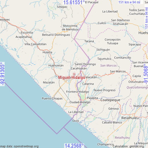
Miguel Hidalgo GPS coordinates[2]
14° 56' 14.028" North, 92° 12' 35.712" West
| Map corner | latitude | longitude |
|---|---|---|
| Upper-left | 15.61551°, | -92.91305° |
| Center: | 14.93723°, | -92.20992° |
| Lower-right: | 14.2568°, | -91.5068° |
| Map W x H: | 151.1×151.1 km | = 93.9×93.9mi |
| max Lat: | 32.7° ⇑99.6% North |
| Miguel Hidalgo: | 14.93723° |
| min Lat: | ⇓0.4% South 14.53588° |
| min Long | Miguel Hidalgo | max Long |
| -117.105° | -92.20992° | -86.73105° |
| W 94%⇐ | ⇒6% E |
Elevation
Elevation of Miguel Hidalgo is 291 m = 955 ft, and this is 962.7 m = 3158 ft below average elevation for this country.
| Max E: |
3497 m = 11473 ft | 72.9% |
| Avg. | 1253.7 m = 4113 ft | |
| Miguel Hidalgo | 291 m = 955 ft | |
Min E: |
-1 m = -3 ft | 27.1% |
See also: Mexico elevation on elevation.city.
Geographical zone
Miguel Hidalgo is located in North Torrid zone (between Equator and Tropic of Cancer). Distance of this Northern Tropic circle is 945.1 km =587.3 mi to North.| Distance of | km | miles | from Miguel Hidalgo |
|---|---|---|---|
| North Pole | 8346.2 | 5186.1 | to North |
| Arctic Circle | 5740.3 | 3566.9 | to North |
| Tropic Cancer | 945.1 | 587.3 | to North |
| Equator | 1660.9 | 1032 | to South |


Nearby cities:
15 places around Miguel Hidalgo: (largest is in red/bold)
• 1ra. Sección de Izapa
4.6 km =2.9 mi,  113°
113°
• 2da. Sección de Medio Monte
6.7 km =4.2 mi,  155°
155°
• El Chaparrón
5.9 km =3.7 mi,  319°
319°
• El Sacrificio
7.4 km =4.6 mi,  195°
195°
• El Triunfo
6.1 km =3.8 mi,  347°
347°
• Hermosillo
6.5 km =4 mi,  12°
12°
• Los Encinos
6.7 km =4.2 mi,  206°
206°
• Manga de Clavo
6.4 km =4 mi,  288°
288°
• Manuel Lazos
4.5 km =2.8 mi,  32°
32°
• San Agustín Jitotol
6.6 km =4.1 mi, 354°
• Sección la Toma
5.7 km =3.5 mi,  60°
60°
• Silvano Gatica
2.5 km =1.6 mi, 10°
• Talismán
7.3 km =4.5 mi,  66°
66°
• Tapachula
6.3 km =3.9 mi,  234°
234°
• Tuxtla Chico
4.6 km =2.9 mi,  86°
86°
Sources, notices
• [Note1] Compared only with cities in Mexico existing in our database
• [Src1] Map data: © OpenStreetMap contributors (CC-BY-SA)
• [Src2] Other city data from geonames.org with taken over terms of usage.
• [Src3] Geographical zone / Annual Mean Temperature by Robert A. Rohde @ Wikipedia
