Solosuchiapa geodata
Solosuchiapa (Chiapas) is a seat of a second-order administrative division; located in Mexico in America/Mexico_City (GMT-6) time zone. With population of 2,035 people, there are 4286 cities with bigger population in this country. Compared to other cities in Mexico, 83.9% of cities are located further ↑North; 88.3% of cities are located further ←West and 76.6% of cities have higher elevation than Solosuchiapa. Note1


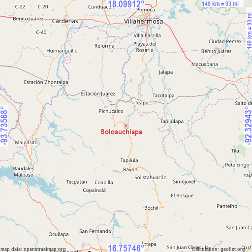
Solosuchiapa GPS coordinates[2]
17° 25' 46.272" North, 93° 1' 57.18" West
| Map corner | latitude | longitude |
|---|---|---|
| Upper-left | 18.09912°, | -93.73568° |
| Center: | 17.42952°, | -93.03255° |
| Lower-right: | 16.75746°, | -92.32943° |
| Map W x H: | 149.2×149.2 km | = 92.7×92.7mi |
| max Lat: | 32.7° ⇑83.9% North |
| Solosuchiapa: | 17.42952° |
| min Lat: | ⇓16.1% South 14.53588° |
| min Long | Solosuchiapa | max Long |
| -117.105° | -93.03255° | -86.73105° |
| W 88.3%⇐ | ⇒11.7% E |
Elevation
Elevation of Solosuchiapa is 164 m = 538 ft, and this is 1089.7 m = 3575 ft below average elevation for this country.
| Max E: |
3497 m = 11473 ft | 76.6% |
| Avg. | 1253.7 m = 4113 ft | |
| Solosuchiapa | 164 m = 538 ft | |
Min E: |
-1 m = -3 ft | 23.4% |
See also: Mexico elevation on elevation.city.
Geographical zone
Solosuchiapa is located in North Torrid zone (between Equator and Tropic of Cancer). Distance of this Northern Tropic circle is 667.9 km =415 mi to North.| Distance of | km | miles | from Solosuchiapa |
|---|---|---|---|
| North Pole | 8069.1 | 5013.9 | to North |
| Arctic Circle | 5463.2 | 3394.7 | to North |
| Tropic Cancer | 667.9 | 415 | to North |
| Equator | 1938 | 1204.2 | to South |


Nearby cities:
15 places around Solosuchiapa: (largest is in red/bold)
• Cerro las Campanas
12.3 km =7.6 mi,  149°
149°
• Chapultenango
14.3 km =8.9 mi,  226°
226°
• Emiliano Zapata
7.9 km =4.9 mi,  294°
294°
• Francisco I. Madero
12.2 km =7.6 mi,  83°
83°
• Ixtacomitán
6.8 km =4.2 mi,  271°
271°
• Ixtapangajoya
8.3 km =5.2 mi,  23°
23°
• La Gloria
8.5 km =5.3 mi, 80°
• Lázaro Cárdenas
10.9 km =6.8 mi,  119°
119°
• Monte Horeb
10 km =6.2 mi,  162°
162°
• Napana
11.7 km =7.3 mi,  321°
321°
• Pichucalco
12.6 km =7.8 mi, 315°
• Río Negro
12.9 km =8 mi,  214°
214°
• Tectuapan
13.6 km =8.5 mi,  278°
278°
• Villaflores
11.2 km =7 mi,  136°
136°
• Álvaro Obregón
6.1 km =3.8 mi,  134°
134°
Sources, notices
• [Note1] Compared only with cities in Mexico existing in our database
• [Src1] Map data: © OpenStreetMap contributors (CC-BY-SA)
• [Src2] Other city data from geonames.org with taken over terms of usage.
• [Src3] Geographical zone / Annual Mean Temperature by Robert A. Rohde @ Wikipedia
