La Gloria geodata
La Gloria (Chiapas) is a populated place; located in Mexico in America/Mexico_City (GMT-6) time zone. With population of 1,478 people, there are 5841 cities with bigger population in this country. Compared to other cities in Mexico, 83.7% of cities are located further ↑North; 88.9% of cities are located further ←West and 65.5% of cities have higher elevation than La Gloria. Note1


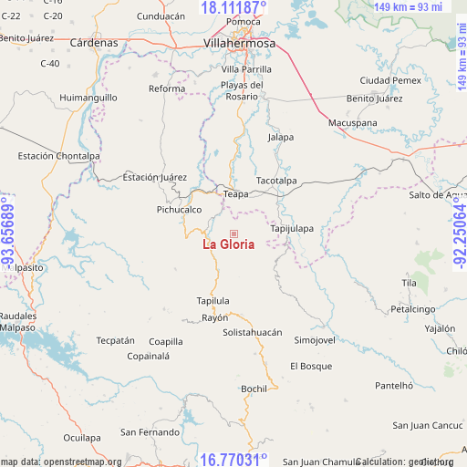
La Gloria GPS coordinates[2]
17° 26' 32.352" North, 92° 57' 13.536" West
| Map corner | latitude | longitude |
|---|---|---|
| Upper-left | 18.11187°, | -93.65689° |
| Center: | 17.44232°, | -92.95376° |
| Lower-right: | 16.77031°, | -92.25064° |
| Map W x H: | 149.2×149.2 km | = 92.7×92.7mi |
| max Lat: | 32.7° ⇑83.7% North |
| La Gloria: | 17.44232° |
| min Lat: | ⇓16.3% South 14.53588° |
| min Long | La Gloria | max Long |
| -117.105° | -92.95376° | -86.73105° |
| W 88.9%⇐ | ⇒11.1% E |
Elevation
Elevation of La Gloria is 659 m = 2162 ft, and this is 594.7 m = 1951 ft below average elevation for this country.
| Max E: |
3497 m = 11473 ft | 65.5% |
| Avg. | 1253.7 m = 4113 ft | |
| La Gloria | 659 m = 2162 ft | |
Min E: |
-1 m = -3 ft | 34.5% |
See also: Mexico elevation on elevation.city.
Geographical zone
La Gloria is located in North Torrid zone (between Equator and Tropic of Cancer). Distance of this Northern Tropic circle is 666.5 km =414.1 mi to North.| Distance of | km | miles | from La Gloria |
|---|---|---|---|
| North Pole | 8067.7 | 5013 | to North |
| Arctic Circle | 5461.8 | 3393.8 | to North |
| Tropic Cancer | 666.5 | 414.1 | to North |
| Equator | 1939.4 | 1205.1 | to South |


Nearby cities:
15 places around La Gloria: (largest is in red/bold)
• Cerro las Campanas
12.2 km =7.6 mi,  189°
189°
• Eureka y Belén
13.3 km =8.3 mi,  11°
11°
• Francisco I. Madero
3.7 km =2.3 mi,  92°
92°
• Guadalupe Victoria
11.9 km =7.4 mi,  133°
133°
• Ignacio Allende 2da. Sección
12.8 km =8 mi,  343°
343°
• Ixtapangajoya
8 km =5 mi,  320°
320°
• Lázaro Cárdenas
6.9 km =4.3 mi,  170°
170°
• Mariano Abasolo
11.7 km =7.3 mi,  352°
352°
• Monte Horeb
12.2 km =7.6 mi,  206°
206°
• Reforma y Planada
11.2 km =7 mi,  123°
123°
• Solosuchiapa
8.5 km =5.3 mi,  260°
260°
• Teapa
11.9 km =7.4 mi,  0°
0°
• Vicente Guerrero
8.6 km =5.3 mi,  22°
22°
• Villaflores
9.6 km =6 mi,  184°
184°
• Álvaro Obregón
6.9 km =4.3 mi, 214°
Sources, notices
• [Note1] Compared only with cities in Mexico existing in our database
• [Src1] Map data: © OpenStreetMap contributors (CC-BY-SA)
• [Src2] Other city data from geonames.org with taken over terms of usage.
• [Src3] Geographical zone / Annual Mean Temperature by Robert A. Rohde @ Wikipedia
