Lázaro Cárdenas geodata
Lázaro Cárdenas (Chiapas) is a populated place; located in Mexico in America/Mexico_City (GMT-6) time zone. With population of 703 people, there are 12379 cities with bigger population in this country. Compared to other cities in Mexico, 84.4% of cities are located further ↑North; 89% of cities are located further ←West and 66.5% of cities have higher elevation than Lázaro Cárdenas. Note1


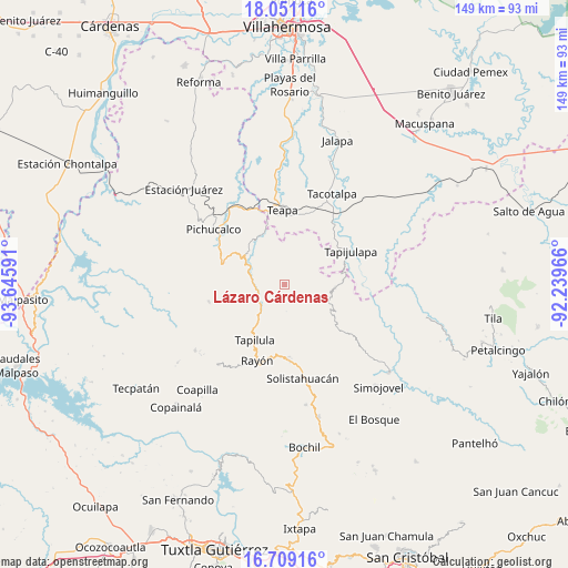
Lázaro Cárdenas GPS coordinates[2]
17° 22' 53.004" North, 92° 56' 34.008" West
| Map corner | latitude | longitude |
|---|---|---|
| Upper-left | 18.05116°, | -93.64591° |
| Center: | 17.38139°, | -92.94278° |
| Lower-right: | 16.70916°, | -92.23966° |
| Map W x H: | 149.2×149.2 km | = 92.7×92.7mi |
| max Lat: | 32.7° ⇑84.4% North |
| Lázaro Cárdenas: | 17.38139° |
| min Lat: | ⇓15.6% South 14.53588° |
| min Long | Lázaro Cárden | max Long |
| -117.105° | -92.94278° | -86.73105° |
| W 89%⇐ | ⇒11% E |
Elevation
Elevation of Lázaro Cárdenas is 610 m = 2001 ft, and this is 643.7 m = 2112 ft below average elevation for this country.
| Max E: |
3497 m = 11473 ft | 66.5% |
| Avg. | 1253.7 m = 4113 ft | |
| Lázaro Cárdenas | 610 m = 2001 ft | |
Min E: |
-1 m = -3 ft | 33.5% |
See also: Mexico elevation on elevation.city.
Geographical zone
Lázaro Cárdenas is located in North Torrid zone (between Equator and Tropic of Cancer). Distance of this Northern Tropic circle is 673.3 km =418.4 mi to North.| Distance of | km | miles | from Lázaro Cárdenas |
|---|---|---|---|
| North Pole | 8074.4 | 5017.2 | to North |
| Arctic Circle | 5468.5 | 3398 | to North |
| Tropic Cancer | 673.3 | 418.4 | to North |
| Equator | 1932.6 | 1200.9 | to South |


Nearby cities:
15 places around Lázaro Cárdenas: (largest is in red/bold)
• Cerro las Campanas
6.1 km =3.8 mi,  211°
211°
• Chapallal Grande
9.5 km =5.9 mi,  181°
181°
• El Porvenir Tres Picos
9.2 km =5.7 mi,  119°
119°
• Francisco I. Madero
7.1 km =4.4 mi,  21°
21°
• Guadalupe Victoria
7.7 km =4.8 mi,  100°
100°
• Ignacio Zaragoza
10.2 km =6.3 mi, 177°
• La Gloria
6.9 km =4.3 mi,  350°
350°
• Monte Horeb
7.7 km =4.8 mi,  237°
237°
• Reforma y Planada
8.2 km =5.1 mi,  85°
85°
• San Antonio Tres Picos
10.8 km =6.7 mi,  126°
126°
• San José Chapayal
10.6 km =6.6 mi,  148°
148°
• Santa Anita
10 km =6.2 mi,  201°
201°
• Solosuchiapa
10.9 km =6.8 mi,  299°
299°
• Villaflores
3.4 km =2.1 mi, 214°
• Álvaro Obregón
5.2 km =3.2 mi,  281°
281°
Sources, notices
• [Note1] Compared only with cities in Mexico existing in our database
• [Src1] Map data: © OpenStreetMap contributors (CC-BY-SA)
• [Src2] Other city data from geonames.org with taken over terms of usage.
• [Src3] Geographical zone / Annual Mean Temperature by Robert A. Rohde @ Wikipedia
