Ixtapangajoya geodata
Ixtapangajoya (Chiapas) is a seat of a second-order administrative division; located in Mexico in America/Mexico_City (GMT-6) time zone. With population of 1,272 people, there are 6810 cities with bigger population in this country. Compared to other cities in Mexico, 83.2% of cities are located further ↑North; 88.6% of cities are located further ←West and 79.3% of cities have higher elevation than Ixtapangajoya. Note1


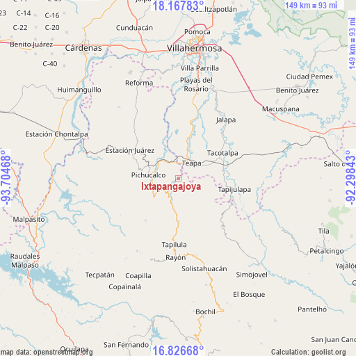
Ixtapangajoya GPS coordinates[2]
17° 29' 54.564" North, 93° 0' 5.58" West
| Map corner | latitude | longitude |
|---|---|---|
| Upper-left | 18.16783°, | -93.70468° |
| Center: | 17.49849°, | -93.00155° |
| Lower-right: | 16.82668°, | -92.29843° |
| Map W x H: | 149.1×149.1 km | = 92.6×92.6mi |
| max Lat: | 32.7° ⇑83.2% North |
| Ixtapangajoya: | 17.49849° |
| min Lat: | ⇓16.8% South 14.53588° |
| min Long | Ixtapangajoya | max Long |
| -117.105° | -93.00155° | -86.73105° |
| W 88.6%⇐ | ⇒11.4% E |
Elevation
Elevation of Ixtapangajoya is 106 m = 348 ft, and this is 1147.7 m = 3765 ft below average elevation for this country.
| Max E: |
3497 m = 11473 ft | 79.3% |
| Avg. | 1253.7 m = 4113 ft | |
| Ixtapangajoya | 106 m = 348 ft | |
Min E: |
-1 m = -3 ft | 20.7% |
See also: Mexico elevation on elevation.city.
Geographical zone
Ixtapangajoya is located in North Torrid zone (between Equator and Tropic of Cancer). Distance of this Northern Tropic circle is 660.3 km =410.3 mi to North.| Distance of | km | miles | from Ixtapangajoya |
|---|---|---|---|
| North Pole | 8061.4 | 5009.1 | to North |
| Arctic Circle | 5455.5 | 3389.9 | to North |
| Tropic Cancer | 660.3 | 410.3 | to North |
| Equator | 1945.6 | 1208.9 | to South |


Nearby cities:
15 places around Ixtapangajoya: (largest is in red/bold)
• Chapultepec
8 km =5 mi,  22°
22°
• Colonia Municipal
10.6 km =6.6 mi,  12°
12°
• Emiliano Zapata
11.3 km =7 mi,  247°
247°
• Eureka y Belén
10.3 km =6.4 mi,  48°
48°
• Francisco I. Madero
10.9 km =6.8 mi,  125°
125°
• Ignacio Allende 2da. Sección
6.2 km =3.9 mi, 13°
• La Gloria
8 km =5 mi,  140°
140°
• Manuel Buelta 2da. Sección
9.7 km =6 mi, 24°
• Mariano Abasolo
6.4 km =4 mi,  32°
32°
• Napana
10.6 km =6.6 mi,  278°
278°
• Pichucalco
12.2 km =7.6 mi, 276°
• Solosuchiapa
8.3 km =5.2 mi,  203°
203°
• Teapa
7.7 km =4.8 mi,  42°
42°
• Vicente Guerrero
8.6 km =5.3 mi,  78°
78°
• Álvaro Obregón
12 km =7.5 mi,  174°
174°
Sources, notices
• [Note1] Compared only with cities in Mexico existing in our database
• [Src1] Map data: © OpenStreetMap contributors (CC-BY-SA)
• [Src2] Other city data from geonames.org with taken over terms of usage.
• [Src3] Geographical zone / Annual Mean Temperature by Robert A. Rohde @ Wikipedia
