Santiago Jocotepec geodata
Santiago Jocotepec (Oaxaca) is a populated place; located in Mexico in America/Mexico_City (GMT-6) time zone. With population of 1,767 people, there are 4916 cities with bigger population in this country. Compared to other cities in Mexico, 96.8% of cities are located further ↑North; 70.2% of cities are located further ←West and 65.6% of cities have higher elevation than Santiago Jocotepec. Note1


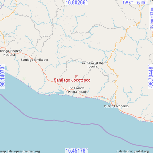
Santiago Jocotepec GPS coordinates[2]
16° 7' 42.132" North, 97° 26' 15.36" West
| Map corner | latitude | longitude |
|---|---|---|
| Upper-left | 16.80266°, | -98.14073° |
| Center: | 16.12837°, | -97.4376° |
| Lower-right: | 15.45178°, | -96.73448° |
| Map W x H: | 150.2×150.2 km | = 93.3×93.3mi |
| max Lat: | 32.7° ⇑96.8% North |
| Santiago Jocotepec: | 16.12837° |
| min Lat: | ⇓3.2% South 14.53588° |
| min Long | Santiago Jocote | max Long |
| -117.105° | -97.4376° | -86.73105° |
| W 70.2%⇐ | ⇒29.8% E |
Elevation
Elevation of Santiago Jocotepec is 657 m = 2156 ft, and this is 596.7 m = 1958 ft below average elevation for this country.
| Max E: |
3497 m = 11473 ft | 65.6% |
| Avg. | 1253.7 m = 4113 ft | |
| Santiago Jocotepec | 657 m = 2156 ft | |
Min E: |
-1 m = -3 ft | 34.4% |
See also: Mexico elevation on elevation.city.
Geographical zone
Santiago Jocotepec is located in North Torrid zone (between Equator and Tropic of Cancer). Distance of this Northern Tropic circle is 812.6 km =504.9 mi to North.| Distance of | km | miles | from Santiago Jocotepec |
|---|---|---|---|
| North Pole | 8213.8 | 5103.8 | to North |
| Arctic Circle | 5607.9 | 3484.6 | to North |
| Tropic Cancer | 812.6 | 504.9 | to North |
| Equator | 1793.3 | 1114.3 | to South |


Nearby cities:
15 places around Santiago Jocotepec: (largest is in red/bold)
• Ampliación Barrio Grande y la Asunción
19.2 km =11.9 mi,  52°
52°
• El Cacalote
21.4 km =13.3 mi,  154°
154°
• El Zapotalito
20.3 km =12.6 mi,  216°
216°
• La Luz
17 km =10.6 mi,  264°
264°
• Peñas Negras
12.2 km =7.6 mi,  333°
333°
• Río Grande
13.1 km =8.1 mi,  179°
179°
• San Marcos Zacatepec
8.7 km =5.4 mi,  78°
78°
• San Miguel
19.6 km =12.2 mi,  248°
248°
• San Miguel Panixtlahuaca
16 km =9.9 mi,  23°
23°
• Santa Ana Tututepec
11.6 km =7.2 mi,  301°
301°
• Santa Catarina Juquila
19.8 km =12.3 mi, 51°
• Santa María Acatepec
8.3 km =5.2 mi,  285°
285°
• Santa Rosa de Lima
20.8 km =12.9 mi, 252°
• Santiago Yaitepec
21 km =13 mi,  58°
58°
• Tepenixtlahuaca
19.1 km =11.9 mi,  342°
342°
Sources, notices
• [Note1] Compared only with cities in Mexico existing in our database
• [Src1] Map data: © OpenStreetMap contributors (CC-BY-SA)
• [Src2] Other city data from geonames.org with taken over terms of usage.
• [Src3] Geographical zone / Annual Mean Temperature by Robert A. Rohde @ Wikipedia
