Río Grande geodata
Río Grande (Oaxaca) is a populated place; located in Mexico in America/Mexico_City (GMT-6) time zone. With population of 12,943 people, there are 759 cities with bigger population in this country. Compared to other cities in Mexico, 97.2% of cities are located further ↑North; 70.2% of cities are located further ←West and 89.4% of cities have higher elevation than Río Grande. Note1


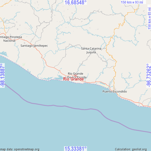
Río Grande GPS coordinates[2]
16° 0' 38.844" North, 97° 26' 8.664" West
| Map corner | latitude | longitude |
|---|---|---|
| Upper-left | 16.68548°, | -98.13887° |
| Center: | 16.01079°, | -97.43574° |
| Lower-right: | 15.33381°, | -96.73262° |
| Map W x H: | 150.3×150.3 km | = 93.4×93.4mi |
| max Lat: | 32.7° ⇑97.2% North |
| Río Grande: | 16.01079° |
| min Lat: | ⇓2.8% South 14.53588° |
| min Long | Río Grande | max Long |
| -117.105° | -97.43574° | -86.73105° |
| W 70.2%⇐ | ⇒29.8% E |
Elevation
Elevation of Río Grande is 26 m = 85 ft, and this is 1227.7 m = 4028 ft below average elevation for this country.
| Max E: |
3497 m = 11473 ft | 89.4% |
| Avg. | 1253.7 m = 4113 ft | |
| Río Grande | 26 m = 85 ft | |
Min E: |
-1 m = -3 ft | 10.6% |
See also: Mexico elevation on elevation.city.
Geographical zone
Río Grande is located in North Torrid zone (between Equator and Tropic of Cancer). Distance of this Northern Tropic circle is 825.7 km =513.1 mi to North.| Distance of | km | miles | from Río Grande |
|---|---|---|---|
| North Pole | 8226.8 | 5111.9 | to North |
| Arctic Circle | 5620.9 | 3492.7 | to North |
| Tropic Cancer | 825.7 | 513.1 | to North |
| Equator | 1780.2 | 1106.2 | to South |


Nearby cities:
15 places around Río Grande: (largest is in red/bold)
• Cerro del Aire
27.1 km =16.8 mi,  65°
65°
• El Cacalote
10.9 km =6.8 mi,  125°
125°
• El Zapotalito
12.7 km =7.9 mi,  255°
255°
• Hidalgo Manialtepec
20.3 km =12.6 mi,  106°
106°
• La Luz
20.6 km =12.8 mi,  304°
304°
• Peñas Negras
24.6 km =15.3 mi,  346°
346°
• San José Manialtepec
20.9 km =13 mi,  101°
101°
• San Marcos Zacatepec
17 km =10.6 mi,  29°
29°
• San Miguel
19.4 km =12.1 mi,  287°
287°
• Santa Ana Tututepec
21.6 km =13.4 mi,  332°
332°
• Santa Lucía Teotepec
28.3 km =17.6 mi,  58°
58°
• Santa María Acatepec
17.4 km =10.8 mi, 331°
• Santa Rosa de Lima
21.1 km =13.1 mi, 288°
• Santiago Cuixtla
27.3 km =17 mi,  77°
77°
• Santiago Jocotepec
13.1 km =8.1 mi,  359°
359°
Sources, notices
• [Note1] Compared only with cities in Mexico existing in our database
• [Src1] Map data: © OpenStreetMap contributors (CC-BY-SA)
• [Src2] Other city data from geonames.org with taken over terms of usage.
• [Src3] Geographical zone / Annual Mean Temperature by Robert A. Rohde @ Wikipedia
