La Luz geodata
La Luz (Oaxaca) is a populated place; located in Mexico in America/Mexico_City (GMT-6) time zone. With population of 2,444 people, there are 3615 cities with bigger population in this country. Compared to other cities in Mexico, 96.8% of cities are located further ↑North; 68.5% of cities are located further ←West and 83.4% of cities have higher elevation than La Luz. Note1


La Luz GPS coordinates[2]
16° 6' 53.172" North, 97° 35' 44.52" West
| Map corner | latitude | longitude |
|---|---|---|
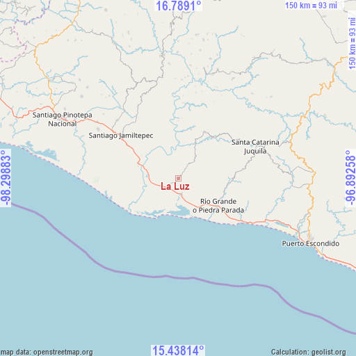
| Upper-left | 16.7891°, | -98.29883° |
| Center: | 16.11477°, | -97.5957° |
| Lower-right: | 15.43814°, | -96.89258° |
| Map W x H: | 150.2×150.2 km | = 93.3×93.3mi |
| max Lat: | 32.7° ⇑96.8% North |
| La Luz: | 16.11477° |
| min Lat: | ⇓3.2% South 14.53588° |
| min Long | La Luz | max Long |
| -117.105° | -97.5957° | -86.73105° |
| W 68.5%⇐ | ⇒31.5% E |
Elevation
Elevation of La Luz is 57 m = 187 ft, and this is 1196.7 m = 3926 ft below average elevation for this country.
| Max E: |
3497 m = 11473 ft | 83.4% |
| Avg. | 1253.7 m = 4113 ft | |
| La Luz | 57 m = 187 ft | |
Min E: |
-1 m = -3 ft | 16.6% |
See also: Mexico elevation on elevation.city.
Geographical zone
La Luz is located in North Torrid zone (between Equator and Tropic of Cancer). Distance of this Northern Tropic circle is 814.1 km =505.9 mi to North.| Distance of | km | miles | from La Luz |
|---|---|---|---|
| North Pole | 8215.3 | 5104.7 | to North |
| Arctic Circle | 5609.4 | 3485.5 | to North |
| Tropic Cancer | 814.1 | 505.9 | to North |
| Equator | 1791.8 | 1113.4 | to South |


Nearby cities:
15 places around La Luz: (largest is in red/bold)
• Charco Nduayoo
17.9 km =11.1 mi,  290°
290°
• El Zapotalito
15.6 km =9.7 mi,  161°
161°
• Paso de la Reina
15.2 km =9.4 mi,  359°
359°
• Patria Nueva
22.8 km =14.2 mi, 288°
• Peñas Negras
16.8 km =10.4 mi,  42°
42°
• Río Grande
20.6 km =12.8 mi,  124°
124°
• San José Río Verde (La Boquilla)
17 km =10.6 mi,  278°
278°
• San José del Progreso
10.8 km =6.7 mi,  258°
258°
• San Miguel
5.8 km =3.6 mi,  193°
193°
• Santa Ana Tututepec
10.2 km =6.3 mi, 42°
• Santa María Acatepec
9.6 km =6 mi,  67°
67°
• Santa Rosa de Lima
5.7 km =3.5 mi,  211°
211°
• Santiago Jocotepec
17 km =10.6 mi,  84°
84°
• Tataltepec de Valdés
21.9 km =13.6 mi,  14°
14°
• Tepenixtlahuaca
22.6 km =14 mi,  29°
29°
Sources, notices
• [Note1] Compared only with cities in Mexico existing in our database
• [Src1] Map data: © OpenStreetMap contributors (CC-BY-SA)
• [Src2] Other city data from geonames.org with taken over terms of usage.
• [Src3] Geographical zone / Annual Mean Temperature by Robert A. Rohde @ Wikipedia
