Santa Rosa de Lima geodata
Santa Rosa de Lima (Oaxaca) is a populated place; located in Mexico in America/Mexico_City (GMT-6) time zone. With population of 2,200 people, there are 3989 cities with bigger population in this country. Compared to other cities in Mexico, 97% of cities are located further ↑North; 68.2% of cities are located further ←West and 90.8% of cities have higher elevation than Santa Rosa de Lima. Note1


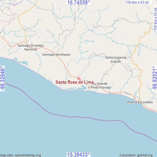
Santa Rosa de Lima GPS coordinates[2]
16° 4' 15.996" North, 97° 37' 23.988" West
| Map corner | latitude | longitude |
|---|---|---|
| Upper-left | 16.74559°, | -98.32646° |
| Center: | 16.07111°, | -97.62333° |
| Lower-right: | 15.39433°, | -96.92021° |
| Map W x H: | 150.2×150.2 km | = 93.3×93.3mi |
| max Lat: | 32.7° ⇑97% North |
| Santa Rosa de Lima: | 16.07111° |
| min Lat: | ⇓3% South 14.53588° |
| min Long | Santa Rosa de L | max Long |
| -117.105° | -97.62333° | -86.73105° |
| W 68.2%⇐ | ⇒31.8% E |
Elevation
Elevation of Santa Rosa de Lima is 22 m = 72 ft, and this is 1231.7 m = 4041 ft below average elevation for this country.
| Max E: |
3497 m = 11473 ft | 90.8% |
| Avg. | 1253.7 m = 4113 ft | |
| Santa Rosa de Lima | 22 m = 72 ft | |
Min E: |
-1 m = -3 ft | 9.2% |
See also: Mexico elevation on elevation.city.
Geographical zone
Santa Rosa de Lima is located in North Torrid zone (between Equator and Tropic of Cancer). Distance of this Northern Tropic circle is 819 km =508.9 mi to North.| Distance of | km | miles | from Santa Rosa de Lima |
|---|---|---|---|
| North Pole | 8220.1 | 5107.7 | to North |
| Arctic Circle | 5614.2 | 3488.5 | to North |
| Tropic Cancer | 819 | 508.9 | to North |
| Equator | 1786.9 | 1110.3 | to South |


Nearby cities:
15 places around Santa Rosa de Lima: (largest is in red/bold)
• Charco Nduayoo
17.7 km =11 mi,  308°
308°
• El Azufre
19.4 km =12.1 mi,  241°
241°
• El Zapotalito
12.7 km =7.9 mi,  141°
141°
• La Luz
5.7 km =3.5 mi,  31°
31°
• Paso de la Reina
20.2 km =12.6 mi,  8°
8°
• Patria Nueva
22.3 km =13.9 mi,  303°
303°
• Peñas Negras
22.4 km =13.9 mi,  39°
39°
• Río Grande
21.1 km =13.1 mi,  108°
108°
• San José Río Verde (La Boquilla)
15.7 km =9.8 mi, 297°
• San José del Progreso
8.1 km =5 mi,  289°
289°
• San Miguel
1.8 km =1.1 mi,  117°
117°
• Santa Ana Tututepec
15.9 km =9.9 mi, 38°
• Santa María Acatepec
14.6 km =9.1 mi,  53°
53°
• Santiago Jocotepec
20.8 km =12.9 mi,  72°
72°
• Tataltepec de Valdés
27.3 km =17 mi,  17°
17°
Sources, notices
• [Note1] Compared only with cities in Mexico existing in our database
• [Src1] Map data: © OpenStreetMap contributors (CC-BY-SA)
• [Src2] Other city data from geonames.org with taken over terms of usage.
• [Src3] Geographical zone / Annual Mean Temperature by Robert A. Rohde @ Wikipedia
