El Cacalote geodata
El Cacalote (Oaxaca) is a populated place; located in Mexico in America/Mexico_City (GMT-6) time zone. With population of 763 people, there are 11483 cities with bigger population in this country. Compared to other cities in Mexico, 97.4% of cities are located further ↑North; 71% of cities are located further ←West and 97% of cities have higher elevation than El Cacalote. Note1


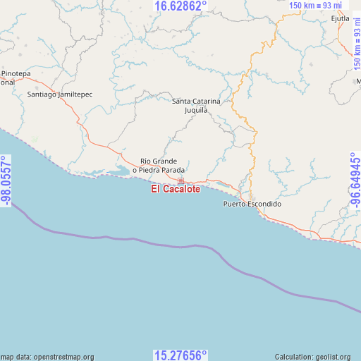
El Cacalote GPS coordinates[2]
15° 57' 13.428" North, 97° 21' 9.252" West
| Map corner | latitude | longitude |
|---|---|---|
| Upper-left | 16.62862°, | -98.0557° |
| Center: | 15.95373°, | -97.35257° |
| Lower-right: | 15.27656°, | -96.64945° |
| Map W x H: | 150.3×150.3 km | = 93.4×93.4mi |
| max Lat: | 32.7° ⇑97.4% North |
| El Cacalote: | 15.95373° |
| min Lat: | ⇓2.6% South 14.53588° |
| min Long | El Cacalote | max Long |
| -117.105° | -97.35257° | -86.73105° |
| W 71%⇐ | ⇒29% E |
Elevation
Elevation of El Cacalote is 10 m = 33 ft, and this is 1243.7 m = 4080 ft below average elevation for this country.
| Max E: |
3497 m = 11473 ft | 97% |
| Avg. | 1253.7 m = 4113 ft | |
| El Cacalote | 10 m = 33 ft | |
Min E: |
-1 m = -3 ft | 3% |
See also: Mexico elevation on elevation.city.
Geographical zone
El Cacalote is located in North Torrid zone (between Equator and Tropic of Cancer). Distance of this Northern Tropic circle is 832 km =517 mi to North.| Distance of | km | miles | from El Cacalote |
|---|---|---|---|
| North Pole | 8233.2 | 5115.9 | to North |
| Arctic Circle | 5627.3 | 3496.6 | to North |
| Tropic Cancer | 832 | 517 | to North |
| Equator | 1773.9 | 1102.3 | to South |


Nearby cities:
15 places around El Cacalote: (largest is in red/bold)
• Bajos de Chila
25 km =15.5 mi,  97°
97°
• Cerro del Aire
23.5 km =14.6 mi,  42°
42°
• El Zapotalito
21.3 km =13.2 mi,  278°
278°
• Hidalgo Manialtepec
10.6 km =6.6 mi,  86°
86°
• Río Grande
10.9 km =6.8 mi,  305°
305°
• San Andrés Copala
22.8 km =14.2 mi,  77°
77°
• San José Atotonilco
24.9 km =15.5 mi,  47°
47°
• San José Manialtepec
11.8 km =7.3 mi, 78°
• San Marcos Zacatepec
21.1 km =13.1 mi,  358°
358°
• Santa Lucía Teotepec
26 km =16.2 mi, 36°
• Santa María Acatepec
27.6 km =17.1 mi,  321°
321°
• Santa María Tiltepec
22.9 km =14.2 mi,  58°
58°
• Santiago Cuixtla
21.5 km =13.4 mi, 55°
• Santiago Jocotepec
21.4 km =13.3 mi,  334°
334°
• Santos Reyes Nopala
28 km =17.4 mi, 52°
Sources, notices
• [Note1] Compared only with cities in Mexico existing in our database
• [Src1] Map data: © OpenStreetMap contributors (CC-BY-SA)
• [Src2] Other city data from geonames.org with taken over terms of usage.
• [Src3] Geographical zone / Annual Mean Temperature by Robert A. Rohde @ Wikipedia
