Santiago Choápam geodata
Santiago Choápam (Oaxaca) is a populated place; located in Mexico in America/Mexico_City (GMT-6) time zone. With population of 1,099 people, there are 7916 cities with bigger population in this country. Compared to other cities in Mexico, 84.6% of cities are located further ↑North; 82.4% of cities are located further ←West and 61.4% of cities have higher elevation than Santiago Choápam. Note1


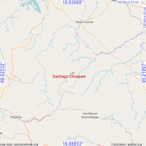
Santiago Choápam GPS coordinates[2]
17° 21' 39.024" North, 95° 55' 19.884" West
| Map corner | latitude | longitude |
|---|---|---|
| Upper-left | 18.03069°, | -96.62532° |
| Center: | 17.36084°, | -95.92219° |
| Lower-right: | 16.68853°, | -95.21907° |
| Map W x H: | 149.2×149.2 km | = 92.7×92.7mi |
| max Lat: | 32.7° ⇑84.6% North |
| Santiago Choápam: | 17.36084° |
| min Lat: | ⇓15.4% South 14.53588° |
| min Long | Santiago Choáp | max Long |
| -117.105° | -95.92219° | -86.73105° |
| W 82.4%⇐ | ⇒17.6% E |
Elevation
Elevation of Santiago Choápam is 911 m = 2989 ft, and this is 342.7 m = 1124 ft below average elevation for this country.
| Max E: |
3497 m = 11473 ft | 61.4% |
| Avg. | 1253.7 m = 4113 ft | |
| Santiago Choápam | 911 m = 2989 ft | |
Min E: |
-1 m = -3 ft | 38.6% |
See also: Mexico elevation on elevation.city.
Geographical zone
Santiago Choápam is located in North Torrid zone (between Equator and Tropic of Cancer). Distance of this Northern Tropic circle is 675.6 km =419.8 mi to North.| Distance of | km | miles | from Santiago Choápam |
|---|---|---|---|
| North Pole | 8076.7 | 5018.6 | to North |
| Arctic Circle | 5470.8 | 3399.4 | to North |
| Tropic Cancer | 675.6 | 419.8 | to North |
| Equator | 1930.3 | 1199.4 | to South |


Nearby cities:
15 places around Santiago Choápam: (largest is in red/bold)
• Arroyo Blanco
20.9 km =13 mi,  17°
17°
• Chinantequilla
9.9 km =6.2 mi,  234°
234°
• Ignacio Zaragoza
19.7 km =12.2 mi,  8°
8°
• La Candelaria
15.9 km =9.9 mi,  184°
184°
• Lachixova
6.8 km =4.2 mi,  223°
223°
• San Francisco Jayacaxtepec
16.4 km =10.2 mi,  199°
199°
• San Juan Metaltepec
20.6 km =12.8 mi, 176°
• San Juan Petlapa
17.1 km =10.6 mi,  314°
314°
• Santiago Jalahui
19.2 km =11.9 mi,  56°
56°
• Santiago Jocotepec
19.6 km =12.2 mi,  353°
353°
• Santiago Tepitongo
13.3 km =8.3 mi,  240°
240°
• Santiago Zacatepec
22.3 km =13.9 mi, 177°
• Santo Domingo Latani
2.5 km =1.6 mi, 61°
• Santo Domingo Roayaga
20.6 km =12.8 mi,  262°
262°
• Totontepec Villa de Morelos
16.1 km =10 mi, 224°
Sources, notices
• [Note1] Compared only with cities in Mexico existing in our database
• [Src1] Map data: © OpenStreetMap contributors (CC-BY-SA)
• [Src2] Other city data from geonames.org with taken over terms of usage.
• [Src3] Geographical zone / Annual Mean Temperature by Robert A. Rohde @ Wikipedia
