Santiago Zacatepec geodata
Santiago Zacatepec (Oaxaca) is a populated place; located in Mexico in America/Mexico_City (GMT-6) time zone. With population of 2,151 people, there are 4082 cities with bigger population in this country. Compared to other cities in Mexico, 87% of cities are located further ↑North; 82.4% of cities are located further ←West and 50.5% of cities have higher elevation than Santiago Zacatepec. Note1


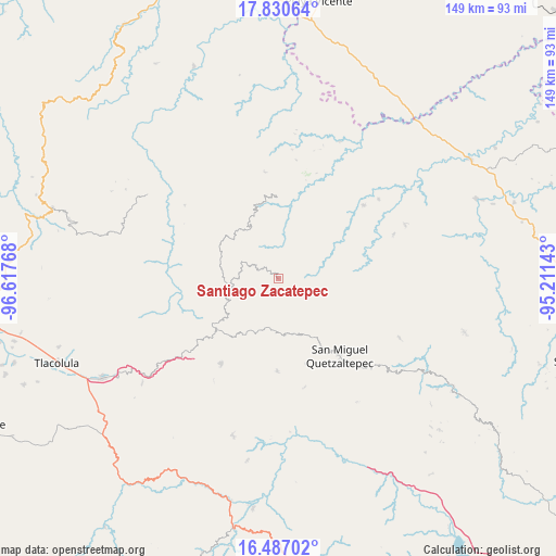
Santiago Zacatepec GPS coordinates[2]
17° 9' 36.18" North, 95° 54' 52.38" West
| Map corner | latitude | longitude |
|---|---|---|
| Upper-left | 17.83064°, | -96.61768° |
| Center: | 17.16005°, | -95.91455° |
| Lower-right: | 16.48702°, | -95.21143° |
| Map W x H: | 149.4×149.4 km | = 92.8×92.8mi |
| max Lat: | 32.7° ⇑87% North |
| Santiago Zacatepec: | 17.16005° |
| min Lat: | ⇓13% South 14.53588° |
| min Long | Santiago Zacate | max Long |
| -117.105° | -95.91455° | -86.73105° |
| W 82.4%⇐ | ⇒17.6% E |
Elevation
Elevation of Santiago Zacatepec is 1402 m = 4600 ft, and this is 148.3 m = 487 ft above average elevation for this country.
| Max E: |
3497 m = 11473 ft | 50.5% |
| Santiago Zacatepec | 1402 m 4600 ft | |
| Avg. | 1253.7 m = 4113 ft | |
Min E: |
-1 m = -3 ft | 49.5% |
See also: Mexico elevation on elevation.city.
Geographical zone
Santiago Zacatepec is located in North Torrid zone (between Equator and Tropic of Cancer). Distance of this Northern Tropic circle is 697.9 km =433.7 mi to North.| Distance of | km | miles | from Santiago Zacatepec |
|---|---|---|---|
| North Pole | 8099 | 5032.5 | to North |
| Arctic Circle | 5493.2 | 3413.3 | to North |
| Tropic Cancer | 697.9 | 433.7 | to North |
| Equator | 1908 | 1185.6 | to South |


Nearby cities:
15 places around Santiago Zacatepec: (largest is in red/bold)
• Cacalotepec
14.5 km =9 mi,  197°
197°
• Cerro Moneda
16.3 km =10.1 mi,  181°
181°
• Estancia de Morelos
12.5 km =7.8 mi,  167°
167°
• Guadalupe Victoria
16.2 km =10.1 mi,  231°
231°
• La Candelaria
6.8 km =4.2 mi,  343°
343°
• San Francisco Jayacaxtepec
9.4 km =5.8 mi,  316°
316°
• San Juan Cotzocón
14 km =8.7 mi,  88°
88°
• San Juan Metaltepec
1.8 km =1.1 mi,  9°
9°
• San Pedro Ayacaxtepec
5.8 km =3.6 mi,  141°
141°
• Santa Ana
16.5 km =10.3 mi,  244°
244°
• Santa María Alotepec
9.9 km =6.2 mi, 139°
• Santiago Altitlán
7 km =4.3 mi,  208°
208°
• Tlahuitoltepec
17.2 km =10.7 mi,  246°
246°
• Totontepec Villa de Morelos
16.1 km =10 mi,  311°
311°
• Yacochi
14.6 km =9.1 mi,  261°
261°
Sources, notices
• [Note1] Compared only with cities in Mexico existing in our database
• [Src1] Map data: © OpenStreetMap contributors (CC-BY-SA)
• [Src2] Other city data from geonames.org with taken over terms of usage.
• [Src3] Geographical zone / Annual Mean Temperature by Robert A. Rohde @ Wikipedia
