Halachó geodata
Halachó (Yucatán) is a seat of a second-order administrative division; located in Mexico in America/Merida (GMT-6) time zone. With population of 9,412 people, there are 1015 cities with bigger population in this country. Compared to other cities in Mexico, 67.3% of cities are located further ↓South; 97.5% of cities are located further ←West and 97% of cities have higher elevation than Halachó. Note1


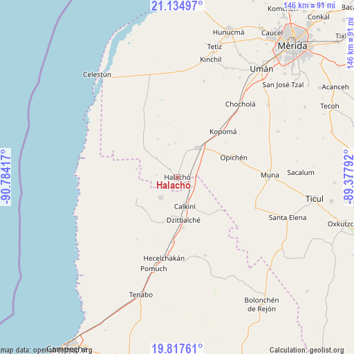
Halachó GPS coordinates[2]
20° 28' 39.72" North, 90° 4' 51.744" West
| Map corner | latitude | longitude |
|---|---|---|
| Upper-left | 21.13497°, | -90.78417° |
| Center: | 20.4777°, | -90.08104° |
| Lower-right: | 19.81761°, | -89.37792° |
| Map W x H: | 146.5×146.5 km | = 91×91mi |
| max Lat: | 32.7° ⇑32.7% North |
| Halachó: | 20.4777° |
| min Lat: | ⇓67.3% South 14.53588° |
| min Long | Halachó | max Long |
| -117.105° | -90.08104° | -86.73105° |
| W 97.5%⇐ | ⇒2.5% E |
Elevation
Elevation of Halachó is 10 m = 33 ft, and this is 1243.7 m = 4080 ft below average elevation for this country.
| Max E: |
3497 m = 11473 ft | 97% |
| Avg. | 1253.7 m = 4113 ft | |
| Halachó | 10 m = 33 ft | |
Min E: |
-1 m = -3 ft | 3% |
See also: Mexico elevation on elevation.city.
Geographical zone
Halachó is located in North Torrid zone (between Equator and Tropic of Cancer). Distance of this Northern Tropic circle is 329 km =204.4 mi to North.| Distance of | km | miles | from Halachó |
|---|---|---|---|
| North Pole | 7730.2 | 4803.3 | to North |
| Arctic Circle | 5124.3 | 3184.1 | to North |
| Tropic Cancer | 329 | 204.4 | to North |
| Equator | 2276.9 | 1414.8 | to South |


Nearby cities:
15 places around Halachó: (largest is in red/bold)
• Bécal
6.9 km =4.3 mi,  125°
125°
• Calkiní
12.5 km =7.8 mi,  165°
165°
• Cepeda
4.3 km =2.7 mi,  316°
316°
• Cuch Holoch
5.1 km =3.2 mi,  199°
199°
• Dzidzibachi
11.3 km =7 mi,  335°
335°
• Dzitbalché
17.9 km =11.1 mi, 171°
• Kochol
17.7 km =11 mi,  332°
332°
• Maxcanú
14.5 km =9 mi,  35°
35°
• Nunkiní
11.1 km =6.9 mi,  219°
219°
• Santa Cruz Pueblo
16.2 km =10.1 mi,  188°
188°
• Santa María Acú
11.5 km =7.1 mi,  311°
311°
• Santa Rosa
14.3 km =8.9 mi,  356°
356°
• Santo Domingo
14.1 km =8.8 mi, 344°
• Tankuché
17.1 km =10.6 mi,  281°
281°
• Tepakán
9.9 km =6.2 mi,  154°
154°
Sources, notices
• [Note1] Compared only with cities in Mexico existing in our database
• [Src1] Map data: © OpenStreetMap contributors (CC-BY-SA)
• [Src2] Other city data from geonames.org with taken over terms of usage.
• [Src3] Geographical zone / Annual Mean Temperature by Robert A. Rohde @ Wikipedia
