Ayoquezco de Aldama geodata
Ayoquezco de Aldama (Oaxaca) is a seat of a second-order administrative division; located in Mexico in America/Mexico_City (GMT-6) time zone. With population of 3,833 people, there are 2384 cities with bigger population in this country. Compared to other cities in Mexico, 93% of cities are located further ↑North; 76.7% of cities are located further ←West and 50.4% of cities have lower elevation than Ayoquezco de Aldama. Note1


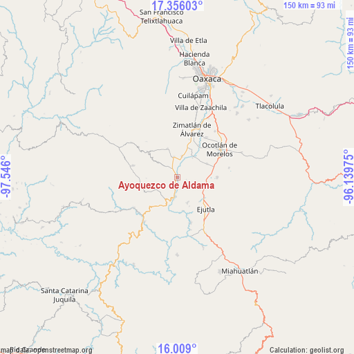
Ayoquezco de Aldama GPS coordinates[2]
16° 41' 1.32" North, 96° 50' 34.332" West
| Map corner | latitude | longitude |
|---|---|---|
| Upper-left | 17.35603°, | -97.546° |
| Center: | 16.6837°, | -96.84287° |
| Lower-right: | 16.009°, | -96.13975° |
| Map W x H: | 149.8×149.8 km | = 93.1×93.1mi |
| max Lat: | 32.7° ⇑93% North |
| Ayoquezco de Aldama: | 16.6837° |
| min Lat: | ⇓7% South 14.53588° |
| min Long | Ayoquezco de Al | max Long |
| -117.105° | -96.84287° | -86.73105° |
| W 76.7%⇐ | ⇒23.3% E |
Elevation
Elevation of Ayoquezco de Aldama is 1451 m = 4760 ft, and this is 197.3 m = 647 ft above average elevation for this country.
| Max E: |
3497 m = 11473 ft | 49.6% |
| Ayoquezco de Aldama | 1451 m 4760 ft | |
| Avg. | 1253.7 m = 4113 ft | |
Min E: |
-1 m = -3 ft | 50.4% |
See also: Mexico elevation on elevation.city.
Geographical zone
Ayoquezco de Aldama is located in North Torrid zone (between Equator and Tropic of Cancer). Distance of this Northern Tropic circle is 750.9 km =466.6 mi to North.| Distance of | km | miles | from Ayoquezco de Aldama |
|---|---|---|---|
| North Pole | 8152 | 5065.4 | to North |
| Arctic Circle | 5546.1 | 3446.2 | to North |
| Tropic Cancer | 750.9 | 466.6 | to North |
| Equator | 1855.1 | 1152.7 | to South |


Nearby cities:
15 places around Ayoquezco de Aldama: (largest is in red/bold)
• Agua Fría Campanario
9.9 km =6.2 mi,  310°
310°
• Agua del Espino
11.2 km =7 mi,  157°
157°
• El Vergel
10.8 km =6.7 mi,  116°
116°
• Emiliano Zapata
8.7 km =5.4 mi,  6°
6°
• La Pe
7.6 km =4.7 mi,  140°
140°
• Monte del Toro
11.1 km =6.9 mi,  93°
93°
• San Andrés Zabache
9.5 km =5.9 mi,  189°
189°
• San Martín Lachila
8 km =5 mi,  184°
184°
• Santa Ana Tlapacoyan
6.7 km =4.2 mi, 5°
• Santa Cruz Nexila
5.6 km =3.5 mi, 188°
• Santa Gertrudis
12.2 km =7.6 mi,  21°
21°
• Santa Martha Chichihualtepec
8.2 km =5.1 mi, 117°
• Tejas de Morelos
11.6 km =7.2 mi,  42°
42°
• Trapiche Santa Cruz
8.8 km =5.5 mi,  352°
352°
• Valdeflores
9.3 km =5.8 mi, 12°
Sources, notices
• [Note1] Compared only with cities in Mexico existing in our database
• [Src1] Map data: © OpenStreetMap contributors (CC-BY-SA)
• [Src2] Other city data from geonames.org with taken over terms of usage.
• [Src3] Geographical zone / Annual Mean Temperature by Robert A. Rohde @ Wikipedia
