Valdeflores geodata
Valdeflores (Oaxaca) is a populated place; located in Mexico in America/Mexico_City (GMT-6) time zone. With population of 1,094 people, there are 7947 cities with bigger population in this country. Compared to other cities in Mexico, 92.1% of cities are located further ↑North; 77% of cities are located further ←West and 50.9% of cities have lower elevation than Valdeflores. Note1


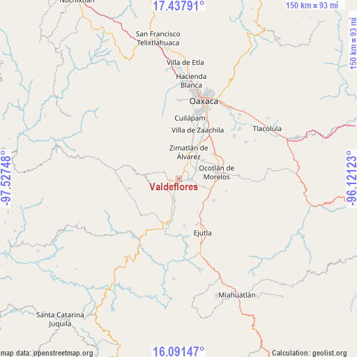
Valdeflores GPS coordinates[2]
16° 45' 57.168" North, 96° 49' 27.66" West
| Map corner | latitude | longitude |
|---|---|---|
| Upper-left | 17.43791°, | -97.52748° |
| Center: | 16.76588°, | -96.82435° |
| Lower-right: | 16.09147°, | -96.12123° |
| Map W x H: | 149.7×149.7 km | = 93×93mi |
| max Lat: | 32.7° ⇑92.1% North |
| Valdeflores: | 16.76588° |
| min Lat: | ⇓7.9% South 14.53588° |
| min Long | Valdeflores | max Long |
| -117.105° | -96.82435° | -86.73105° |
| W 77%⇐ | ⇒23% E |
Elevation
Elevation of Valdeflores is 1478 m = 4849 ft, and this is 224.3 m = 736 ft above average elevation for this country.
| Max E: |
3497 m = 11473 ft | 49.1% |
| Valdeflores | 1478 m 4849 ft | |
| Avg. | 1253.7 m = 4113 ft | |
Min E: |
-1 m = -3 ft | 50.9% |
See also: Mexico elevation on elevation.city.
Geographical zone
Valdeflores is located in North Torrid zone (between Equator and Tropic of Cancer). Distance of this Northern Tropic circle is 741.7 km =460.9 mi to North.| Distance of | km | miles | from Valdeflores |
|---|---|---|---|
| North Pole | 8142.9 | 5059.8 | to North |
| Arctic Circle | 5537 | 3440.5 | to North |
| Tropic Cancer | 741.7 | 460.9 | to North |
| Equator | 1864.2 | 1158.4 | to South |


Nearby cities:
15 places around Valdeflores: (largest is in red/bold)
• Agua Fría Campanario
9.8 km =6.1 mi,  254°
254°
• Asunción Ocotlán
11 km =6.8 mi,  92°
92°
• Ayoquezco de Aldama
9.3 km =5.8 mi,  192°
192°
• Emiliano Zapata
1.1 km =0.7 mi,  243°
243°
• San Bernardo Mixtepec
10.4 km =6.5 mi,  309°
309°
• San José Guelatová de Díaz
5 km =3.1 mi,  58°
58°
• San Nicolás Quialana
9.9 km =6.2 mi,  29°
29°
• San Pablo Huixtepec
7.5 km =4.7 mi,  37°
37°
• Santa Ana Tlapacoyan
2.8 km =1.7 mi,  208°
208°
• Santa Cruz Mixtepec
6.7 km =4.2 mi,  296°
296°
• Santa Gertrudis
3.4 km =2.1 mi,  49°
49°
• Santa Inés Yatzeche
8.5 km =5.3 mi, 57°
• Santa María Vigallo
10.2 km =6.3 mi,  4°
4°
• Tejas de Morelos
5.9 km =3.7 mi,  96°
96°
• Trapiche Santa Cruz
3.2 km =2 mi,  262°
262°
Sources, notices
• [Note1] Compared only with cities in Mexico existing in our database
• [Src1] Map data: © OpenStreetMap contributors (CC-BY-SA)
• [Src2] Other city data from geonames.org with taken over terms of usage.
• [Src3] Geographical zone / Annual Mean Temperature by Robert A. Rohde @ Wikipedia
