Nunkiní geodata
Nunkiní (Campeche) is a populated place; located in Mexico in America/Merida (GMT-6) time zone. With population of 5,859 people, there are 1588 cities with bigger population in this country. Compared to other cities in Mexico, 65.7% of cities are located further ↓South; 97.4% of cities are located further ←West and 97% of cities have higher elevation than Nunkiní. Note1


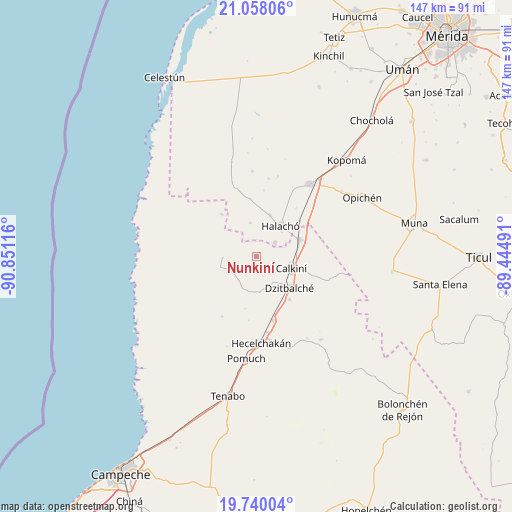
Nunkiní GPS coordinates[2]
20° 24' 1.656" North, 90° 8' 52.908" West
| Map corner | latitude | longitude |
|---|---|---|
| Upper-left | 21.05806°, | -90.85116° |
| Center: | 20.40046°, | -90.14803° |
| Lower-right: | 19.74004°, | -89.44491° |
| Map W x H: | 146.6×146.6 km | = 91.1×91.1mi |
| max Lat: | 32.7° ⇑34.3% North |
| Nunkiní: | 20.40046° |
| min Lat: | ⇓65.7% South 14.53588° |
| min Long | Nunkiní | max Long |
| -117.105° | -90.14803° | -86.73105° |
| W 97.4%⇐ | ⇒2.6% E |
Elevation
Elevation of Nunkiní is 10 m = 33 ft, and this is 1243.7 m = 4080 ft below average elevation for this country.
| Max E: |
3497 m = 11473 ft | 97% |
| Avg. | 1253.7 m = 4113 ft | |
| Nunkiní | 10 m = 33 ft | |
Min E: |
-1 m = -3 ft | 3% |
See also: Mexico elevation on elevation.city.
Geographical zone
Nunkiní is located in North Torrid zone (between Equator and Tropic of Cancer). Distance of this Northern Tropic circle is 337.6 km =209.8 mi to North.| Distance of | km | miles | from Nunkiní |
|---|---|---|---|
| North Pole | 7738.7 | 4808.6 | to North |
| Arctic Circle | 5132.9 | 3189.4 | to North |
| Tropic Cancer | 337.6 | 209.8 | to North |
| Equator | 2268.3 | 1409.5 | to South |


Nearby cities:
15 places around Nunkiní: (largest is in red/bold)
• Bacabchén
15.7 km =9.8 mi,  142°
142°
• Bécal
13.4 km =8.3 mi,  69°
69°
• Calkiní
10.7 km =6.6 mi,  109°
109°
• Cepeda
12.4 km =7.7 mi,  18°
18°
• Cuch Holoch
6.5 km =4 mi,  54°
54°
• Dzidzibachi
18.9 km =11.7 mi,  6°
6°
• Dzitbalché
13.2 km =8.2 mi,  133°
133°
• Halachó
11.1 km =6.9 mi,  39°
39°
• Pucnachén
8.3 km =5.2 mi,  241°
241°
• San Antonio Sahcabchén
10.5 km =6.5 mi,  174°
174°
• Santa Cruz Ex-Hacienda
9.7 km =6 mi,  267°
267°
• Santa Cruz Pueblo
8.8 km =5.5 mi,  147°
147°
• Santa María Acú
16.3 km =10.1 mi,  354°
354°
• Tankuché
15.4 km =9.6 mi,  320°
320°
• Tepakán
11.2 km =7 mi,  91°
91°
Sources, notices
• [Note1] Compared only with cities in Mexico existing in our database
• [Src1] Map data: © OpenStreetMap contributors (CC-BY-SA)
• [Src2] Other city data from geonames.org with taken over terms of usage.
• [Src3] Geographical zone / Annual Mean Temperature by Robert A. Rohde @ Wikipedia
