Zacoalpan geodata
Zacoalpan (Guerrero) is a populated place; located in Mexico in America/Mexico_City (GMT-6) time zone. With population of 4,900 people, there are 1886 cities with bigger population in this country. Compared to other cities in Mexico, 92.3% of cities are located further ↑North; 60% of cities are located further ←West and 75.4% of cities have higher elevation than Zacoalpan. Note1


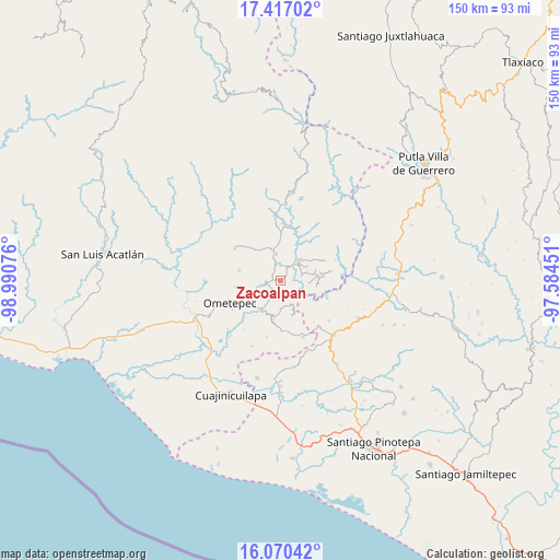
Zacoalpan GPS coordinates[2]
16° 44' 41.676" North, 98° 17' 15.468" West
| Map corner | latitude | longitude |
|---|---|---|
| Upper-left | 17.41702°, | -98.99076° |
| Center: | 16.74491°, | -98.28763° |
| Lower-right: | 16.07042°, | -97.58451° |
| Map W x H: | 149.7×149.7 km | = 93×93mi |
| max Lat: | 32.7° ⇑92.3% North |
| Zacoalpan: | 16.74491° |
| min Lat: | ⇓7.7% South 14.53588° |
| min Long | Zacoalpan | max Long |
| -117.105° | -98.28763° | -86.73105° |
| W 60%⇐ | ⇒40% E |
Elevation
Elevation of Zacoalpan is 207 m = 679 ft, and this is 1046.7 m = 3434 ft below average elevation for this country.
| Max E: |
3497 m = 11473 ft | 75.4% |
| Avg. | 1253.7 m = 4113 ft | |
| Zacoalpan | 207 m = 679 ft | |
Min E: |
-1 m = -3 ft | 24.6% |
See also: Mexico elevation on elevation.city.
Geographical zone
Zacoalpan is located in North Torrid zone (between Equator and Tropic of Cancer). Distance of this Northern Tropic circle is 744.1 km =462.4 mi to North.| Distance of | km | miles | from Zacoalpan |
|---|---|---|---|
| North Pole | 8145.2 | 5061.2 | to North |
| Arctic Circle | 5539.3 | 3442 | to North |
| Tropic Cancer | 744.1 | 462.4 | to North |
| Equator | 1861.9 | 1156.9 | to South |


Nearby cities:
15 places around Zacoalpan: (largest is in red/bold)
• Arroyo Gente
9.7 km =6 mi,  100°
100°
• Cochoapa
9.3 km =5.8 mi,  254°
254°
• Colonia Renacimiento
11.4 km =7.1 mi,  79°
79°
• Cruz Verde II
5.3 km =3.3 mi,  187°
187°
• Cumbre de Barranca Honda
5.4 km =3.4 mi, 254°
• El Santiago
8.9 km =5.5 mi, 78°
• Guadalupe Victoria
11.4 km =7.1 mi, 83°
• Huixtepec
10.3 km =6.4 mi, 190°
• La Concepción
9.8 km =6.1 mi,  162°
162°
• La Guadalupe
6.8 km =4.2 mi, 156°
• Los Liros
7.5 km =4.7 mi,  94°
94°
• Plan de Pierna
9.8 km =6.1 mi,  70°
70°
• Plan de los Muertos
5.7 km =3.5 mi, 78°
• Tlacoachistlahuaca
7.4 km =4.6 mi,  349°
349°
• Xochistlahuaca
7.4 km =4.6 mi,  42°
42°
Sources, notices
• [Note1] Compared only with cities in Mexico existing in our database
• [Src1] Map data: © OpenStreetMap contributors (CC-BY-SA)
• [Src2] Other city data from geonames.org with taken over terms of usage.
• [Src3] Geographical zone / Annual Mean Temperature by Robert A. Rohde @ Wikipedia
