Tlacoachistlahuaca geodata
Tlacoachistlahuaca (Guerrero) is a seat of a second-order administrative division; located in Mexico in America/Mexico_City (GMT-6) time zone. With population of 4,359 people, there are 2102 cities with bigger population in this country. Compared to other cities in Mexico, 91.6% of cities are located further ↑North; 59.9% of cities are located further ←West and 70.1% of cities have higher elevation than Tlacoachistlahuaca. Note1


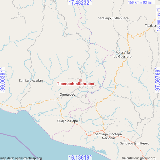
Tlacoachistlahuaca GPS coordinates[2]
16° 48' 37.62" North, 98° 18' 2.808" West
| Map corner | latitude | longitude |
|---|---|---|
| Upper-left | 17.48232°, | -99.00391° |
| Center: | 16.81045°, | -98.30078° |
| Lower-right: | 16.13619°, | -97.59766° |
| Map W x H: | 149.7×149.7 km | = 93×93mi |
| max Lat: | 32.7° ⇑91.6% North |
| Tlacoachistlahuaca: | 16.81045° |
| min Lat: | ⇓8.4% South 14.53588° |
| min Long | Tlacoachistlahu | max Long |
| -117.105° | -98.30078° | -86.73105° |
| W 59.9%⇐ | ⇒40.1% E |
Elevation
Elevation of Tlacoachistlahuaca is 414 m = 1358 ft, and this is 839.7 m = 2755 ft below average elevation for this country.
| Max E: |
3497 m = 11473 ft | 70.1% |
| Avg. | 1253.7 m = 4113 ft | |
| Tlacoachistlahuaca | 414 m = 1358 ft | |
Min E: |
-1 m = -3 ft | 29.9% |
See also: Mexico elevation on elevation.city.
Geographical zone
Tlacoachistlahuaca is located in North Torrid zone (between Equator and Tropic of Cancer). Distance of this Northern Tropic circle is 736.8 km =457.8 mi to North.| Distance of | km | miles | from Tlacoachistlahuaca |
|---|---|---|---|
| North Pole | 8137.9 | 5056.7 | to North |
| Arctic Circle | 5532 | 3437.4 | to North |
| Tropic Cancer | 736.8 | 457.8 | to North |
| Equator | 1869.1 | 1161.4 | to South |


Nearby cities:
15 places around Tlacoachistlahuaca: (largest is in red/bold)
• Cochoapa
12.4 km =7.7 mi,  217°
217°
• Colonia Renacimiento
13.7 km =8.5 mi,  112°
112°
• Cruz Verde II
12.5 km =7.8 mi,  176°
176°
• Cumbre de Barranca Honda
9.6 km =6 mi,  203°
203°
• El Santiago
11.6 km =7.2 mi,  118°
118°
• La Soledad
13.9 km =8.6 mi,  231°
231°
• Los Liros
11.9 km =7.4 mi,  131°
131°
• Plan de Pierna
11.4 km =7.1 mi, 110°
• Plan de los Muertos
9.3 km =5.8 mi, 131°
• San Cristóbal
10.9 km =6.8 mi,  276°
276°
• San Jerónimo
9.9 km =6.2 mi,  319°
319°
• Santa María
10.6 km =6.6 mi,  244°
244°
• Villa Hidalgo
13.9 km =8.6 mi, 227°
• Xochistlahuaca
6.6 km =4.1 mi, 105°
• Zacoalpan
7.4 km =4.6 mi,  169°
169°
Sources, notices
• [Note1] Compared only with cities in Mexico existing in our database
• [Src1] Map data: © OpenStreetMap contributors (CC-BY-SA)
• [Src2] Other city data from geonames.org with taken over terms of usage.
• [Src3] Geographical zone / Annual Mean Temperature by Robert A. Rohde @ Wikipedia
