Santa Inés Tecuexcomac geodata
Santa Inés Tecuexcomac (Puebla) is a populated place; located in Mexico in America/Mexico_City (GMT-6) time zone. With population of 3,041 people, there are 2960 cities with bigger population in this country. Compared to other cities in Mexico, 59% of cities are located further ↑North; 59.3% of cities are located further ←West and 84.1% of cities have lower elevation than Santa Inés Tecuexcomac. Note1


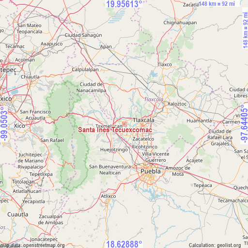
Santa Inés Tecuexcomac GPS coordinates[2]
19° 17' 37.86" North, 98° 20' 49.812" West
| Map corner | latitude | longitude |
|---|---|---|
| Upper-left | 19.95613°, | -99.0503° |
| Center: | 19.29385°, | -98.34717° |
| Lower-right: | 18.62888°, | -97.64405° |
| Map W x H: | 147.6×147.6 km | = 91.7×91.7mi |
| max Lat: | 32.7° ⇑59% North |
| Santa Inés Tecuexcomac: | 19.29385° |
| min Lat: | ⇓41% South 14.53588° |
| min Long | Santa Inés Tec | max Long |
| -117.105° | -98.34717° | -86.73105° |
| W 59.3%⇐ | ⇒40.7% E |
Elevation
Elevation of Santa Inés Tecuexcomac is 2244 m = 7362 ft, and this is 990.3 m = 3249 ft above average elevation for this country.
| Max E: |
3497 m = 11473 ft | 15.9% |
| Santa Inés Tecuexcomac | 2244 m 7362 ft | |
| Avg. | 1253.7 m = 4113 ft | |
Min E: |
-1 m = -3 ft | 84.1% |
See also: Mexico elevation on elevation.city.
Geographical zone
Santa Inés Tecuexcomac is located in North Torrid zone (between Equator and Tropic of Cancer). Distance of this Northern Tropic circle is 460.6 km =286.2 mi to North.| Distance of | km | miles | from Santa Inés Tecuexcomac |
|---|---|---|---|
| North Pole | 7861.8 | 4885.1 | to North |
| Arctic Circle | 5255.9 | 3265.9 | to North |
| Tropic Cancer | 460.6 | 286.2 | to North |
| Equator | 2145.3 | 1333 | to South |


Nearby cities:
15 places around Santa Inés Tecuexcomac: (largest is in red/bold)
• Guadalupe Victoria
4.3 km =2.7 mi,  249°
249°
• San Antonio Tecoac
4.5 km =2.8 mi,  28°
28°
• San Francisco Tenexyecac
3.8 km =2.4 mi,  117°
117°
• San Jorge Tezoquipan
4.7 km =2.9 mi,  49°
49°
• San José Atoyatenco
4.9 km =3 mi,  190°
190°
• San Mateo Ayecac
5.3 km =3.3 mi, 251°
• San Rafael Tenanyecac
5.7 km =3.5 mi,  206°
206°
• Santa Ana Nopalucan
1.5 km =0.9 mi,  72°
72°
• Santa Cruz el Porvenir
4.2 km =2.6 mi,  358°
358°
• Santa Justina Ecatepec
2.1 km =1.3 mi,  336°
336°
• Santiago Xochimilco
5.6 km =3.5 mi,  21°
21°
• Tepetitla
4.4 km =2.7 mi,  224°
224°
• Villa Alta
5.7 km =3.5 mi,  268°
268°
• Villa Mariano Matamoros
4.9 km =3 mi,  318°
318°
• Xocoyucan
3.4 km =2.1 mi,  300°
300°
Sources, notices
• [Note1] Compared only with cities in Mexico existing in our database
• [Src1] Map data: © OpenStreetMap contributors (CC-BY-SA)
• [Src2] Other city data from geonames.org with taken over terms of usage.
• [Src3] Geographical zone / Annual Mean Temperature by Robert A. Rohde @ Wikipedia
