Tepetitla geodata
Tepetitla (Tlaxcala) is a seat of a second-order administrative division; located in Mexico in America/Mexico_City (GMT-6) time zone. With population of 8,316 people, there are 1145 cities with bigger population in this country. Compared to other cities in Mexico, 59.5% of cities are located further ↑North; 58.9% of cities are located further ←West and 83.6% of cities have lower elevation than Tepetitla. Note1


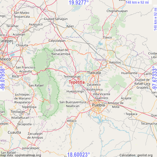
Tepetitla GPS coordinates[2]
19° 15' 55.116" North, 98° 22' 35.22" West
| Map corner | latitude | longitude |
|---|---|---|
| Upper-left | 19.9277°, | -99.07958° |
| Center: | 19.26531°, | -98.37645° |
| Lower-right: | 18.60023°, | -97.67333° |
| Map W x H: | 147.6×147.6 km | = 91.7×91.7mi |
| max Lat: | 32.7° ⇑59.5% North |
| Tepetitla: | 19.26531° |
| min Lat: | ⇓40.5% South 14.53588° |
| min Long | Tepetitla | max Long |
| -117.105° | -98.37645° | -86.73105° |
| W 58.9%⇐ | ⇒41.1% E |
Elevation
Elevation of Tepetitla is 2234 m = 7329 ft, and this is 980.3 m = 3216 ft above average elevation for this country.
| Max E: |
3497 m = 11473 ft | 16.4% |
| Tepetitla | 2234 m 7329 ft | |
| Avg. | 1253.7 m = 4113 ft | |
Min E: |
-1 m = -3 ft | 83.6% |
See also: Mexico elevation on elevation.city.
Geographical zone
Tepetitla is located in North Torrid zone (between Equator and Tropic of Cancer). Distance of this Northern Tropic circle is 463.8 km =288.2 mi to North.| Distance of | km | miles | from Tepetitla |
|---|---|---|---|
| North Pole | 7865 | 4887.1 | to North |
| Arctic Circle | 5259.1 | 3267.9 | to North |
| Tropic Cancer | 463.8 | 288.2 | to North |
| Equator | 2142.1 | 1331 | to South |


Nearby cities:
15 places around Tepetitla: (largest is in red/bold)
• Guadalupe Victoria
1.9 km =1.2 mi,  329°
329°
• Guadalupe Victoria
5.7 km =3.5 mi,  129°
129°
• Moyotzingo
3.5 km =2.2 mi,  237°
237°
• San José Atoyatenco
2.7 km =1.7 mi, 125°
• San Mateo Ayecac
2.4 km =1.5 mi,  308°
308°
• San Miguel Xochitecatitla
3.8 km =2.4 mi,  141°
141°
• San Miguel del Milagro
5.2 km =3.2 mi,  120°
120°
• San Rafael Tenanyecac
2 km =1.2 mi,  164°
164°
• Santa Ana Nopalucan
5.8 km =3.6 mi,  51°
51°
• Santa Ana Xalmimilulco
5.9 km =3.7 mi,  185°
185°
• Santa Inés Tecuexcomac
4.4 km =2.7 mi,  44°
44°
• Santa Justina Ecatepec
5.5 km =3.4 mi,  23°
23°
• Tianguismanalco
5.6 km =3.5 mi, 241°
• Villa Alta
4 km =2.5 mi,  319°
319°
• Xocoyucan
4.9 km =3 mi,  2°
2°
Sources, notices
• [Note1] Compared only with cities in Mexico existing in our database
• [Src1] Map data: © OpenStreetMap contributors (CC-BY-SA)
• [Src2] Other city data from geonames.org with taken over terms of usage.
• [Src3] Geographical zone / Annual Mean Temperature by Robert A. Rohde @ Wikipedia
