Guadalupe Victoria geodata
Guadalupe Victoria (Tlaxcala) is a populated place; located in Mexico in America/Mexico_City (GMT-6) time zone. With population of 855 people, there are 10232 cities with bigger population in this country. Compared to other cities in Mexico, 59.2% of cities are located further ↑North; 58.8% of cities are located further ←West and 83.3% of cities have lower elevation than Guadalupe Victoria. Note1


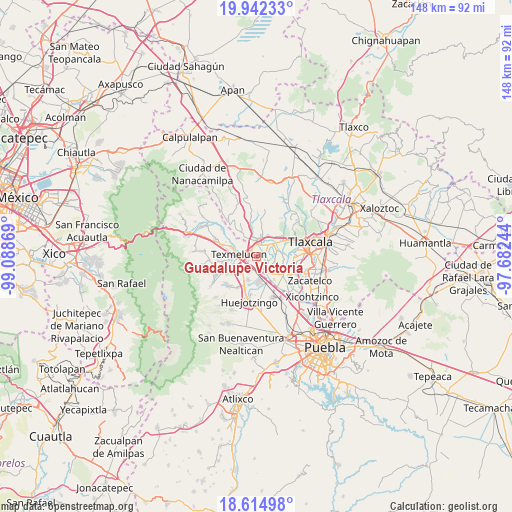
Guadalupe Victoria GPS coordinates[2]
19° 16' 48" North, 98° 23' 8.016" West
| Map corner | latitude | longitude |
|---|---|---|
| Upper-left | 19.94233°, | -99.08869° |
| Center: | 19.28°, | -98.38556° |
| Lower-right: | 18.61498°, | -97.68244° |
| Map W x H: | 147.6×147.6 km | = 91.7×91.7mi |
| max Lat: | 32.7° ⇑59.2% North |
| Guadalupe Victoria: | 19.28° |
| min Lat: | ⇓40.8% South 14.53588° |
| min Long | Guadalupe Victo | max Long |
| -117.105° | -98.38556° | -86.73105° |
| W 58.8%⇐ | ⇒41.2% E |
Elevation
Elevation of Guadalupe Victoria is 2225 m = 7300 ft, and this is 971.3 m = 3187 ft above average elevation for this country.
| Max E: |
3497 m = 11473 ft | 16.7% |
| Guadalupe Victoria | 2225 m 7300 ft | |
| Avg. | 1253.7 m = 4113 ft | |
Min E: |
-1 m = -3 ft | 83.3% |
See also: Mexico elevation on elevation.city.
Geographical zone
Guadalupe Victoria is located in North Torrid zone (between Equator and Tropic of Cancer). Distance of this Northern Tropic circle is 462.2 km =287.2 mi to North.| Distance of | km | miles | from Guadalupe Victoria |
|---|---|---|---|
| North Pole | 7863.3 | 4886 | to North |
| Arctic Circle | 5257.4 | 3266.8 | to North |
| Tropic Cancer | 462.2 | 287.2 | to North |
| Equator | 2143.7 | 1332 | to South |


Nearby cities:
15 places around Guadalupe Victoria: (largest is in red/bold)
• Moyotzingo
4.1 km =2.5 mi,  209°
209°
• San Francisco Tepeyecac
6.5 km =4 mi,  237°
237°
• San José Atoyatenco
4.5 km =2.8 mi,  135°
135°
• San Martin Texmelucan de Labastida
5.6 km =3.5 mi,  274°
274°
• San Mateo Ayecac
1 km =0.6 mi,  263°
263°
• San Miguel Xochitecatitla
5.6 km =3.5 mi, 144°
• San Rafael Tenanyecac
3.9 km =2.4 mi,  157°
157°
• Santa Ana Nopalucan
5.9 km =3.7 mi,  69°
69°
• Santa Inés Tecuexcomac
4.3 km =2.7 mi, 69°
• Santa Justina Ecatepec
4.7 km =2.9 mi,  43°
43°
• Tepetitla
1.9 km =1.2 mi,  149°
149°
• Tianguismanalco
5.8 km =3.6 mi,  222°
222°
• Villa Alta
2.2 km =1.4 mi,  310°
310°
• Villa Mariano Matamoros
5.2 km =3.2 mi,  8°
8°
• Xocoyucan
3.5 km =2.2 mi,  19°
19°
Sources, notices
• [Note1] Compared only with cities in Mexico existing in our database
• [Src1] Map data: © OpenStreetMap contributors (CC-BY-SA)
• [Src2] Other city data from geonames.org with taken over terms of usage.
• [Src3] Geographical zone / Annual Mean Temperature by Robert A. Rohde @ Wikipedia
