Santa Justina Ecatepec geodata
Santa Justina Ecatepec (Tlaxcala) is a populated place; located in Mexico in America/Mexico_City (GMT-6) time zone. With population of 4,616 people, there are 1994 cities with bigger population in this country. Compared to other cities in Mexico, 58.6% of cities are located further ↑North; 59.2% of cities are located further ←West and 84.6% of cities have lower elevation than Santa Justina Ecatepec. Note1
Current local time in Santa Justina Ecatepec:
06:50 AM, WednesdayDifference from your time zone: hours


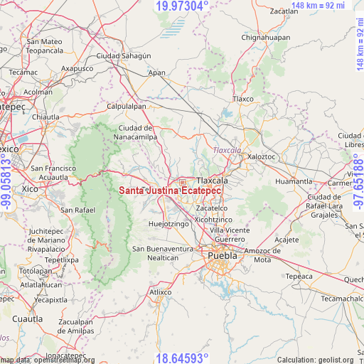
Santa Justina Ecatepec GPS coordinates[2]
19° 18' 38.988" North, 98° 21' 18" West
| Map corner | latitude | longitude |
|---|---|---|
| Upper-left | 19.97304°, | -99.05813° |
| Center: | 19.31083°, | -98.355° |
| Lower-right: | 18.64593°, | -97.65188° |
| Map W x H: | 147.6×147.6 km | = 91.7×91.7mi |
| max Lat: | 32.7° ⇑58.6% North |
| Santa Justina Ecatepec: | 19.31083° |
| min Lat: | ⇓41.4% South 14.53588° |
| min Long | Santa Justina E | max Long |
| -117.105° | -98.355° | -86.73105° |
| W 59.2%⇐ | ⇒40.8% E |
Elevation
Elevation of Santa Justina Ecatepec is 2252 m = 7388 ft, and this is 998.3 m = 3275 ft above average elevation for this country.
| Max E: |
3497 m = 11473 ft | 15.4% |
| Santa Justina Ecatepec | 2252 m 7388 ft | |
| Avg. | 1253.7 m = 4113 ft | |
Min E: |
-1 m = -3 ft | 84.6% |
See also: Mexico elevation on elevation.city.
Geographical zone
Santa Justina Ecatepec is located in North Torrid zone (between Equator and Tropic of Cancer). Distance of this Northern Tropic circle is 458.8 km =285.1 mi to North.| Distance of | km | miles | from Santa Justina Ecatepec |
|---|---|---|---|
| North Pole | 7859.9 | 4883.9 | to North |
| Arctic Circle | 5254 | 3264.7 | to North |
| Tropic Cancer | 458.8 | 285.1 | to North |
| Equator | 2147.2 | 1334.2 | to South |


Nearby cities:
15 places around Santa Justina Ecatepec: (largest is in red/bold)
• Guadalupe Victoria
4.7 km =2.9 mi,  223°
223°
• La Trinidad Tenexyecac
5.1 km =3.2 mi,  56°
56°
• San Antonio Tecoac
3.7 km =2.3 mi,  54°
54°
• San Francisco Tenexyecac
5.5 km =3.4 mi,  131°
131°
• San Jorge Tezoquipan
4.5 km =2.8 mi,  75°
75°
• San José Atoyatenco
6.7 km =4.2 mi,  180°
180°
• San Mateo Ayecac
5.5 km =3.4 mi,  229°
229°
• Santa Ana Nopalucan
2.7 km =1.7 mi,  121°
121°
• Santa Cruz el Porvenir
2.4 km =1.5 mi,  17°
17°
• Santa Inés Tecuexcomac
2.1 km =1.3 mi,  156°
156°
• Santiago Xochimilco
4.4 km =2.7 mi,  41°
41°
• Tepetitla
5.5 km =3.4 mi,  203°
203°
• Villa Alta
5.2 km =3.2 mi,  247°
247°
• Villa Mariano Matamoros
3 km =1.9 mi,  305°
305°
• Xocoyucan
2.1 km =1.3 mi,  265°
265°
Sources, notices
• [Note1] Compared only with cities in Mexico existing in our database
• [Src1] Map data: © OpenStreetMap contributors (CC-BY-SA)
• [Src2] Other city data from geonames.org with taken over terms of usage.
• [Src3] Geographical zone / Annual Mean Temperature by Robert A. Rohde @ Wikipedia
