San Pablo Atlazalpan geodata
San Pablo Atlazalpan (State of Mexico) is a populated place; located in Mexico in America/Mexico_City (GMT-6) time zone. With population of 11,236 people, there are 849 cities with bigger population in this country. Compared to other cities in Mexico, 60.8% of cities are located further ↑North; 51.8% of cities are located further ←West and 84.6% of cities have lower elevation than San Pablo Atlazalpan. Note1
Current local time in San Pablo Atlazalpan:
08:28 AM, WednesdayDifference from your time zone: hours


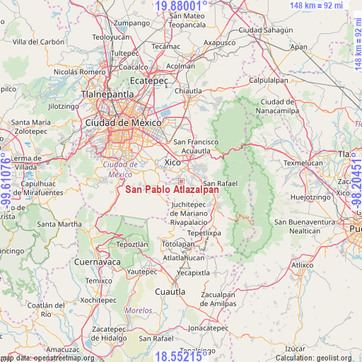
San Pablo Atlazalpan GPS coordinates[2]
19° 13' 2.712" North, 98° 54' 27.468" West
| Map corner | latitude | longitude |
|---|---|---|
| Upper-left | 19.88001°, | -99.61076° |
| Center: | 19.21742°, | -98.90763° |
| Lower-right: | 18.55215°, | -98.20451° |
| Map W x H: | 147.6×147.6 km | = 91.7×91.7mi |
| max Lat: | 32.7° ⇑60.8% North |
| San Pablo Atlazalpan: | 19.21742° |
| min Lat: | ⇓39.2% South 14.53588° |
| min Long | San Pablo Atlaz | max Long |
| -117.105° | -98.90763° | -86.73105° |
| W 51.8%⇐ | ⇒48.2% E |
Elevation
Elevation of San Pablo Atlazalpan is 2252 m = 7388 ft, and this is 998.3 m = 3275 ft above average elevation for this country.
| Max E: |
3497 m = 11473 ft | 15.4% |
| San Pablo Atlazalpan | 2252 m 7388 ft | |
| Avg. | 1253.7 m = 4113 ft | |
Min E: |
-1 m = -3 ft | 84.6% |
See also: Mexico elevation on elevation.city.
Geographical zone
San Pablo Atlazalpan is located in North Torrid zone (between Equator and Tropic of Cancer). Distance of this Northern Tropic circle is 469.1 km =291.5 mi to North.| Distance of | km | miles | from San Pablo Atlazalpan |
|---|---|---|---|
| North Pole | 7870.3 | 4890.4 | to North |
| Arctic Circle | 5264.4 | 3271.1 | to North |
| Tropic Cancer | 469.1 | 291.5 | to North |
| Equator | 2136.8 | 1327.7 | to South |


Nearby cities:
15 places around San Pablo Atlazalpan: (largest is in red/bold)
• Barrio de Guadalupe
2.8 km =1.7 mi,  300°
300°
• Caserío de Cortés
5.3 km =3.3 mi,  246°
246°
• Chalco
5 km =3.1 mi,  11°
11°
• Cocotitlán
4.7 km =2.9 mi,  67°
67°
• Colonia Michoacana
1.5 km =0.9 mi,  194°
194°
• Colonia San José
1.4 km =0.9 mi,  137°
137°
• El Recodo de San José Axalco
1.7 km =1.1 mi,  162°
162°
• Lomas de San Pablo
2 km =1.2 mi,  212°
212°
• Los Reyes Acatlixhuayán
2.8 km =1.7 mi,  109°
109°
• San Ignacio de Loyola
5.2 km =3.2 mi,  268°
268°
• San Juan y San Pedro Tezompa
5.7 km =3.5 mi,  258°
258°
• San Mateo Huitzilzingo
2.2 km =1.4 mi,  305°
305°
• Santa Catarina Ayotzingo
2.5 km =1.6 mi, 249°
• Temamatla
4.3 km =2.7 mi, 111°
• Zula
1.9 km =1.2 mi,  81°
81°
Sources, notices
• [Note1] Compared only with cities in Mexico existing in our database
• [Src1] Map data: © OpenStreetMap contributors (CC-BY-SA)
• [Src2] Other city data from geonames.org with taken over terms of usage.
• [Src3] Geographical zone / Annual Mean Temperature by Robert A. Rohde @ Wikipedia
