San Pablo Hidalgo geodata
San Pablo Hidalgo (Morelos) is a populated place; located in Mexico in America/Mexico_City (GMT-6) time zone. With population of 540 people, there are 15727 cities with bigger population in this country. Compared to other cities in Mexico, 71.6% of cities are located further ↑North; 50.4% of cities are located further →East and 61.2% of cities have higher elevation than San Pablo Hidalgo. Note1


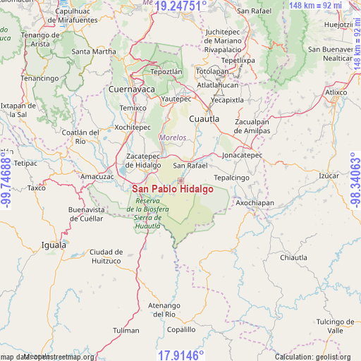
San Pablo Hidalgo GPS coordinates[2]
18° 34' 56.496" North, 99° 2' 37.5" West
| Map corner | latitude | longitude |
|---|---|---|
| Upper-left | 19.24751°, | -99.74688° |
| Center: | 18.58236°, | -99.04375° |
| Lower-right: | 17.9146°, | -98.34063° |
| Map W x H: | 148.2×148.2 km | = 92.1×92.1mi |
| max Lat: | 32.7° ⇑71.6% North |
| San Pablo Hidalgo: | 18.58236° |
| min Lat: | ⇓28.4% South 14.53588° |
| min Long | San Pablo Hidal | max Long |
| -117.105° | -99.04375° | -86.73105° |
| W 49.6%⇐ | ⇒50.4% E |
Elevation
Elevation of San Pablo Hidalgo is 925 m = 3035 ft, and this is 328.7 m = 1078 ft below average elevation for this country.
| Max E: |
3497 m = 11473 ft | 61.2% |
| Avg. | 1253.7 m = 4113 ft | |
| San Pablo Hidalgo | 925 m = 3035 ft | |
Min E: |
-1 m = -3 ft | 38.8% |
See also: Mexico elevation on elevation.city.
Geographical zone
San Pablo Hidalgo is located in North Torrid zone (between Equator and Tropic of Cancer). Distance of this Northern Tropic circle is 539.8 km =335.4 mi to North.| Distance of | km | miles | from San Pablo Hidalgo |
|---|---|---|---|
| North Pole | 7940.9 | 4934.2 | to North |
| Arctic Circle | 5335 | 3315 | to North |
| Tropic Cancer | 539.8 | 335.4 | to North |
| Equator | 2066.2 | 1283.9 | to South |


Nearby cities:
15 places around San Pablo Hidalgo: (largest is in red/bold)
• Chinameca
6.6 km =4.1 mi,  47°
47°
• Colonia 3 de Mayo (El Tepiolol)
12.7 km =7.9 mi,  296°
296°
• El Salitre
13.8 km =8.6 mi,  40°
40°
• El Vergel
1.2 km =0.7 mi, 46°
• Huitchila
14 km =8.7 mi,  63°
63°
• La Mezquitera
6.4 km =4 mi,  249°
249°
• Lorenzo Vázquez (Santa Cruz)
3.2 km =2 mi, 252°
• Palo Grande
11 km =6.8 mi,  276°
276°
• Pedro Amaro
13.7 km =8.5 mi, 276°
• Quilamula
8.4 km =5.2 mi,  161°
161°
• San Rafael Zaragoza
7.8 km =4.8 mi,  32°
32°
• San Vicente de Juárez
12.8 km =8 mi, 28°
• Tlaquiltenango
13.8 km =8.6 mi,  294°
294°
• Valle de Vázquez
6.6 km =4.1 mi,  204°
204°
• Zacapalco
10.9 km =6.8 mi, 54°
Sources, notices
• [Note1] Compared only with cities in Mexico existing in our database
• [Src1] Map data: © OpenStreetMap contributors (CC-BY-SA)
• [Src2] Other city data from geonames.org with taken over terms of usage.
• [Src3] Geographical zone / Annual Mean Temperature by Robert A. Rohde @ Wikipedia
