Quilamula geodata
Quilamula (Morelos) is a populated place; located in Mexico in America/Mexico_City (GMT-6) time zone. With population of 703 people, there are 12379 cities with bigger population in this country. Compared to other cities in Mexico, 72.5% of cities are located further ↑North; 50.1% of cities are located further →East and 58.4% of cities have higher elevation than Quilamula. Note1


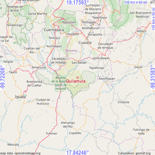
Quilamula GPS coordinates[2]
18° 30' 37.764" North, 99° 1' 8.22" West
| Map corner | latitude | longitude |
|---|---|---|
| Upper-left | 19.17593°, | -99.72208° |
| Center: | 18.51049°, | -99.01895° |
| Lower-right: | 17.84246°, | -98.31583° |
| Map W x H: | 148.3×148.3 km | = 92.1×92.1mi |
| max Lat: | 32.7° ⇑72.5% North |
| Quilamula: | 18.51049° |
| min Lat: | ⇓27.5% South 14.53588° |
| min Long | Quilamula | max Long |
| -117.105° | -99.01895° | -86.73105° |
| W 49.9%⇐ | ⇒50.1% E |
Elevation
Elevation of Quilamula is 1085 m = 3560 ft, and this is 168.7 m = 553 ft below average elevation for this country.
| Max E: |
3497 m = 11473 ft | 58.4% |
| Avg. | 1253.7 m = 4113 ft | |
| Quilamula | 1085 m = 3560 ft | |
Min E: |
-1 m = -3 ft | 41.6% |
See also: Mexico elevation on elevation.city.
Geographical zone
Quilamula is located in North Torrid zone (between Equator and Tropic of Cancer). Distance of this Northern Tropic circle is 547.7 km =340.3 mi to North.| Distance of | km | miles | from Quilamula |
|---|---|---|---|
| North Pole | 7948.9 | 4939.2 | to North |
| Arctic Circle | 5343 | 3320 | to North |
| Tropic Cancer | 547.7 | 340.3 | to North |
| Equator | 2058.2 | 1278.9 | to South |


Nearby cities:
15 places around Quilamula: (largest is in red/bold)
• Chinameca
12.6 km =7.8 mi,  10°
10°
• El Vergel
9 km =5.6 mi,  348°
348°
• Higuerón
18.6 km =11.6 mi,  293°
293°
• Huautla
7.9 km =4.9 mi,  184°
184°
• Huitchila
17.3 km =10.7 mi,  34°
34°
• Ixtlilco el Chico
18.9 km =11.7 mi,  73°
73°
• La Mezquitera
10.3 km =6.4 mi,  303°
303°
• Lorenzo Vázquez (Santa Cruz)
9 km =5.6 mi,  321°
321°
• Palo Grande
16.4 km =10.2 mi, 304°
• Pedro Amaro
18.8 km =11.7 mi, 300°
• San Juan Teocalcingo
17.6 km =10.9 mi,  219°
219°
• San Pablo Hidalgo
8.4 km =5.2 mi,  341°
341°
• San Rafael Zaragoza
14.7 km =9.1 mi, 6°
• Valle de Vázquez
5.7 km =3.5 mi, 290°
• Zacapalco
15.6 km =9.7 mi,  23°
23°
Sources, notices
• [Note1] Compared only with cities in Mexico existing in our database
• [Src1] Map data: © OpenStreetMap contributors (CC-BY-SA)
• [Src2] Other city data from geonames.org with taken over terms of usage.
• [Src3] Geographical zone / Annual Mean Temperature by Robert A. Rohde @ Wikipedia
