Chalchihuitán geodata
Chalchihuitán (Chiapas) is a seat of a second-order administrative division; located in Mexico in America/Mexico_City (GMT-6) time zone. With population of 1,054 people, there are 8280 cities with bigger population in this country. Compared to other cities in Mexico, 89.4% of cities are located further ↑North; 91% of cities are located further ←West and 50.8% of cities have lower elevation than Chalchihuitán. Note1


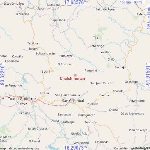
Chalchihuitán GPS coordinates[2]
16° 57' 52.02" North, 92° 37' 8.508" West
| Map corner | latitude | longitude |
|---|---|---|
| Upper-left | 17.63576°, | -93.32216° |
| Center: | 16.96445°, | -92.61903° |
| Lower-right: | 16.29073°, | -91.91591° |
| Map W x H: | 149.6×149.6 km | = 93×93mi |
| max Lat: | 32.7° ⇑89.4% North |
| Chalchihuitán: | 16.96445° |
| min Lat: | ⇓10.6% South 14.53588° |
| min Long | Chalchihuitán | max Long |
| -117.105° | -92.61903° | -86.73105° |
| W 91%⇐ | ⇒9% E |
Elevation
Elevation of Chalchihuitán is 1475 m = 4839 ft, and this is 221.3 m = 726 ft above average elevation for this country.
| Max E: |
3497 m = 11473 ft | 49.2% |
| Chalchihuitán | 1475 m 4839 ft | |
| Avg. | 1253.7 m = 4113 ft | |
Min E: |
-1 m = -3 ft | 50.8% |
See also: Mexico elevation on elevation.city.
Geographical zone
Chalchihuitán is located in North Torrid zone (between Equator and Tropic of Cancer). Distance of this Northern Tropic circle is 719.6 km =447.1 mi to North.| Distance of | km | miles | from Chalchihuitán |
|---|---|---|---|
| North Pole | 8120.8 | 5046 | to North |
| Arctic Circle | 5514.9 | 3426.8 | to North |
| Tropic Cancer | 719.6 | 447.1 | to North |
| Equator | 1886.3 | 1172.1 | to South |


Nearby cities:
15 places around Chalchihuitán: (largest is in red/bold)
• Aldama
9.1 km =5.7 mi,  234°
234°
• Bashequen
8.9 km =5.5 mi,  173°
173°
• Belisario Domínguez
9.2 km =5.7 mi,  208°
208°
• Caridad San Antonio
6.2 km =3.9 mi,  223°
223°
• Chenalhó
7.9 km =4.9 mi,  185°
185°
• Cuchumtón
10.9 km =6.8 mi,  160°
160°
• Jolitontic
9.6 km =6 mi,  347°
347°
• La Libertad
8.7 km =5.4 mi,  140°
140°
• Santiago el Pinar
10.5 km =6.5 mi,  255°
255°
• Suyalhó
10.4 km =6.5 mi,  154°
154°
• Tojtic
10.9 km =6.8 mi, 140°
• Tzoeptic
10.6 km =6.6 mi, 149°
• Yabteclum (Pueblo Viejo)
6.1 km =3.8 mi,  116°
116°
• Yabteclum Fracción Dos
7.2 km =4.5 mi, 121°
• Yaxalumil
6.8 km =4.2 mi, 138°
Sources, notices
• [Note1] Compared only with cities in Mexico existing in our database
• [Src1] Map data: © OpenStreetMap contributors (CC-BY-SA)
• [Src2] Other city data from geonames.org with taken over terms of usage.
• [Src3] Geographical zone / Annual Mean Temperature by Robert A. Rohde @ Wikipedia
