San Miguel Peras geodata
San Miguel Peras (Guerrero) is a populated place; located in Mexico in America/Mexico_City (GMT-6) time zone. With population of 626 people, there are 13818 cities with bigger population in this country. Compared to other cities in Mexico, 85% of cities are located further ↑North; 60.7% of cities are located further ←West and 78.6% of cities have lower elevation than San Miguel Peras. Note1


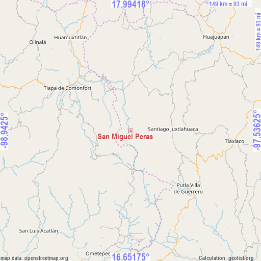
San Miguel Peras GPS coordinates[2]
17° 19' 27.084" North, 98° 14' 21.732" West
| Map corner | latitude | longitude |
|---|---|---|
| Upper-left | 17.99418°, | -98.9425° |
| Center: | 17.32419°, | -98.23937° |
| Lower-right: | 16.65175°, | -97.53625° |
| Map W x H: | 149.3×149.3 km | = 92.8×92.8mi |
| max Lat: | 32.7° ⇑85% North |
| San Miguel Peras: | 17.32419° |
| min Lat: | ⇓15% South 14.53588° |
| min Long | San Miguel Pera | max Long |
| -117.105° | -98.23937° | -86.73105° |
| W 60.7%⇐ | ⇒39.3% E |
Elevation
Elevation of San Miguel Peras is 2103 m = 6900 ft, and this is 849.3 m = 2786 ft above average elevation for this country.
| Max E: |
3497 m = 11473 ft | 21.4% |
| San Miguel Peras | 2103 m 6900 ft | |
| Avg. | 1253.7 m = 4113 ft | |
Min E: |
-1 m = -3 ft | 78.6% |
See also: Mexico elevation on elevation.city.
Geographical zone
San Miguel Peras is located in North Torrid zone (between Equator and Tropic of Cancer). Distance of this Northern Tropic circle is 679.6 km =422.3 mi to North.| Distance of | km | miles | from San Miguel Peras |
|---|---|---|---|
| North Pole | 8080.8 | 5021.2 | to North |
| Arctic Circle | 5474.9 | 3401.9 | to North |
| Tropic Cancer | 679.6 | 422.3 | to North |
| Equator | 1926.3 | 1196.9 | to South |


Nearby cities:
15 places around San Miguel Peras: (largest is in red/bold)
• Ahuajutla
13 km =8.1 mi,  335°
335°
• Almolonga de Ocampo (Almolonga)
16.2 km =10.1 mi,  311°
311°
• Coyul
17 km =10.6 mi,  163°
163°
• Rancho Pastor
8 km =5 mi,  184°
184°
• San Francisco Tlapancingo
18 km =11.2 mi,  350°
350°
• San Juan Piñas
15.1 km =9.4 mi,  137°
137°
• San Marcos Xinicuesta
13.3 km =8.3 mi,  104°
104°
• San Martín Peras
3.9 km =2.4 mi,  3°
3°
• San Miguel el Grande
8.8 km =5.5 mi, 177°
• San Pablo Atzompa
16.3 km =10.1 mi,  238°
238°
• San Vicente Zoyatlán
13.2 km =8.2 mi,  269°
269°
• Santiago Petlacala
5.9 km =3.7 mi, 242°
• Santiago Tilapa
7.6 km =4.7 mi,  197°
197°
• Santos Reyes Zochiquilazola
8.8 km =5.5 mi, 137°
• Tlahuapa
11.8 km =7.3 mi,  298°
298°
Sources, notices
• [Note1] Compared only with cities in Mexico existing in our database
• [Src1] Map data: © OpenStreetMap contributors (CC-BY-SA)
• [Src2] Other city data from geonames.org with taken over terms of usage.
• [Src3] Geographical zone / Annual Mean Temperature by Robert A. Rohde @ Wikipedia
