Ahuajutla geodata
Ahuajutla (Guerrero) is a populated place; located in Mexico in America/Mexico_City (GMT-6) time zone. With population of 1,215 people, there are 7154 cities with bigger population in this country. Compared to other cities in Mexico, 83.8% of cities are located further ↑North; 60% of cities are located further ←West and 57.5% of cities have lower elevation than Ahuajutla. Note1


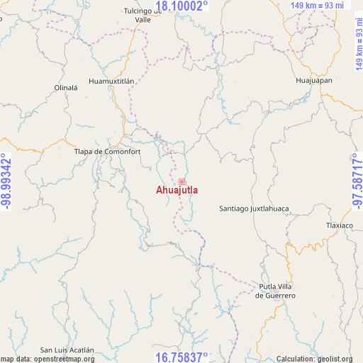
Ahuajutla GPS coordinates[2]
17° 25' 49.548" North, 98° 17' 25.044" West
| Map corner | latitude | longitude |
|---|---|---|
| Upper-left | 18.10002°, | -98.99342° |
| Center: | 17.43043°, | -98.29029° |
| Lower-right: | 16.75837°, | -97.58717° |
| Map W x H: | 149.2×149.2 km | = 92.7×92.7mi |
| max Lat: | 32.7° ⇑83.8% North |
| Ahuajutla: | 17.43043° |
| min Lat: | ⇓16.2% South 14.53588° |
| min Long | Ahuajutla | max Long |
| -117.105° | -98.29029° | -86.73105° |
| W 60%⇐ | ⇒40% E |
Elevation
Elevation of Ahuajutla is 1677 m = 5502 ft, and this is 423.3 m = 1389 ft above average elevation for this country.
| Max E: |
3497 m = 11473 ft | 42.5% |
| Ahuajutla | 1677 m 5502 ft | |
| Avg. | 1253.7 m = 4113 ft | |
Min E: |
-1 m = -3 ft | 57.5% |
See also: Mexico elevation on elevation.city.
Geographical zone
Ahuajutla is located in North Torrid zone (between Equator and Tropic of Cancer). Distance of this Northern Tropic circle is 667.8 km =415 mi to North.| Distance of | km | miles | from Ahuajutla |
|---|---|---|---|
| North Pole | 8069 | 5013.8 | to North |
| Arctic Circle | 5463.1 | 3394.6 | to North |
| Tropic Cancer | 667.8 | 415 | to North |
| Equator | 1938.1 | 1204.3 | to South |


Nearby cities:
15 places around Ahuajutla: (largest is in red/bold)
• Alcozauca de Guerrero
10.7 km =6.6 mi,  290°
290°
• Almolonga de Ocampo (Almolonga)
6.9 km =4.3 mi,  260°
260°
• Calihualá
11.3 km =7 mi,  6°
6°
• Cuyuxtlahuaca
8.1 km =5 mi,  314°
314°
• Guadalupe Nogales
5.8 km =3.6 mi,  340°
340°
• La Luz de Juárez
13.2 km =8.2 mi,  332°
332°
• San Francisco Tlapancingo
6.3 km =3.9 mi,  21°
21°
• San Martín Peras
9.7 km =6 mi,  144°
144°
• San Miguel Peras
13 km =8.1 mi,  155°
155°
• San Vicente Zoyatlán
14.3 km =8.9 mi,  213°
213°
• Santa Cruz
16.5 km =10.3 mi, 313°
• Santiago Petlacala
14.6 km =9.1 mi,  179°
179°
• Tlahuapa
7.9 km =4.9 mi,  219°
219°
• Xochapa
17.8 km =11.1 mi,  253°
253°
• Xonacatlán
15.2 km =9.4 mi,  301°
301°
Sources, notices
• [Note1] Compared only with cities in Mexico existing in our database
• [Src1] Map data: © OpenStreetMap contributors (CC-BY-SA)
• [Src2] Other city data from geonames.org with taken over terms of usage.
• [Src3] Geographical zone / Annual Mean Temperature by Robert A. Rohde @ Wikipedia
