San Pablo Atzompa geodata
San Pablo Atzompa (Guerrero) is a populated place; located in Mexico in America/Mexico_City (GMT-6) time zone. With population of 1,252 people, there are 6922 cities with bigger population in this country. Compared to other cities in Mexico, 85.9% of cities are located further ↑North; 59% of cities are located further ←West and 81.7% of cities have lower elevation than San Pablo Atzompa. Note1


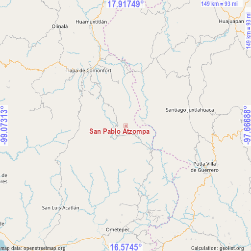
San Pablo Atzompa GPS coordinates[2]
17° 14' 49.992" North, 98° 22' 12" West
| Map corner | latitude | longitude |
|---|---|---|
| Upper-left | 17.91749°, | -99.07313° |
| Center: | 17.24722°, | -98.37° |
| Lower-right: | 16.5745°, | -97.66688° |
| Map W x H: | 149.3×149.3 km | = 92.8×92.8mi |
| max Lat: | 32.7° ⇑85.9% North |
| San Pablo Atzompa: | 17.24722° |
| min Lat: | ⇓14.1% South 14.53588° |
| min Long | San Pablo Atzom | max Long |
| -117.105° | -98.37° | -86.73105° |
| W 59%⇐ | ⇒41% E |
Elevation
Elevation of San Pablo Atzompa is 2181 m = 7156 ft, and this is 927.3 m = 3042 ft above average elevation for this country.
| Max E: |
3497 m = 11473 ft | 18.3% |
| San Pablo Atzompa | 2181 m 7156 ft | |
| Avg. | 1253.7 m = 4113 ft | |
Min E: |
-1 m = -3 ft | 81.7% |
See also: Mexico elevation on elevation.city.
Geographical zone
San Pablo Atzompa is located in North Torrid zone (between Equator and Tropic of Cancer). Distance of this Northern Tropic circle is 688.2 km =427.6 mi to North.| Distance of | km | miles | from San Pablo Atzompa |
|---|---|---|---|
| North Pole | 8089.4 | 5026.5 | to North |
| Arctic Circle | 5483.5 | 3407.3 | to North |
| Tropic Cancer | 688.2 | 427.6 | to North |
| Equator | 1917.7 | 1191.6 | to South |


Nearby cities:
15 places around San Pablo Atzompa: (largest is in red/bold)
• Cochoapa el Grande
10.9 km =6.8 mi,  236°
236°
• Cocuilotlazala
8.5 km =5.3 mi,  314°
314°
• Huexoapa (San Juan Huexoapa)
4.7 km =2.9 mi,  273°
273°
• Lomazóyatl (Lomazoya)
15.3 km =9.5 mi,  321°
321°
• Melchor Ocampo
14.9 km =9.3 mi,  326°
326°
• Metlatónoc
7 km =4.3 mi,  214°
214°
• Rancho Pastor
13.2 km =8.2 mi,  87°
87°
• San Miguel el Grande
14.3 km =8.9 mi, 90°
• San Rafael
6.2 km =3.9 mi,  248°
248°
• San Vicente Zoyatlán
8.4 km =5.2 mi,  4°
4°
• Santiago Petlacala
10.4 km =6.5 mi,  56°
56°
• Santiago Tilapa
11.6 km =7.2 mi,  83°
83°
• Tierra Blanca
10.8 km =6.7 mi,  283°
283°
• Tlahuapa
14.6 km =9.1 mi,  13°
13°
• Yuvinani
4.6 km =2.9 mi, 213°
Sources, notices
• [Note1] Compared only with cities in Mexico existing in our database
• [Src1] Map data: © OpenStreetMap contributors (CC-BY-SA)
• [Src2] Other city data from geonames.org with taken over terms of usage.
• [Src3] Geographical zone / Annual Mean Temperature by Robert A. Rohde @ Wikipedia
