San Miguel Ajusco geodata
San Miguel Ajusco (Mexico City) is a populated place; located in Mexico in America/Mexico_City (GMT-6) time zone. With population of 29,781 people, there are 335 cities with bigger population in this country. Compared to other cities in Mexico, 60.6% of cities are located further ↑North; 52.9% of cities are located further →East and 99.4% of cities have lower elevation than San Miguel Ajusco. Note1


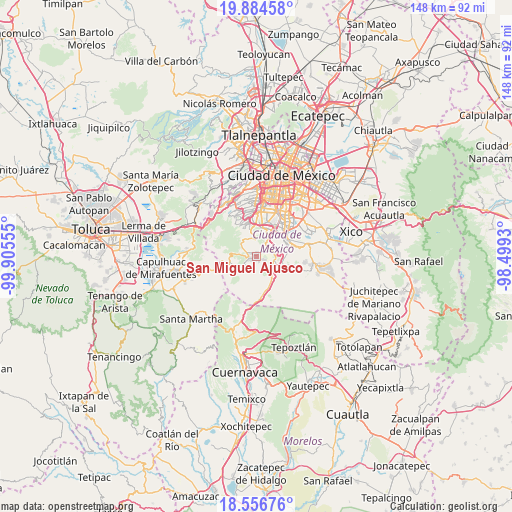
San Miguel Ajusco GPS coordinates[2]
19° 13' 19.236" North, 99° 12' 8.712" West
| Map corner | latitude | longitude |
|---|---|---|
| Upper-left | 19.88458°, | -99.90555° |
| Center: | 19.22201°, | -99.20242° |
| Lower-right: | 18.55676°, | -98.4993° |
| Map W x H: | 147.6×147.6 km | = 91.7×91.7mi |
| max Lat: | 32.7° ⇑60.6% North |
| San Miguel Ajusco: | 19.22201° |
| min Lat: | ⇓39.4% South 14.53588° |
| min Long | San Miguel Ajus | max Long |
| -117.105° | -99.20242° | -86.73105° |
| W 47.1%⇐ | ⇒52.9% E |
Elevation
Elevation of San Miguel Ajusco is 2896 m = 9501 ft, and this is 1642.3 m = 5388 ft above average elevation for this country.
| Max E: |
3497 m = 11473 ft | 0.59999999999999% |
| San Miguel Ajusco | 2896 m 9501 ft | |
| Avg. | 1253.7 m = 4113 ft | |
Min E: |
-1 m = -3 ft | 99.4% |
See also: Mexico elevation on elevation.city.
Geographical zone
San Miguel Ajusco is located in North Torrid zone (between Equator and Tropic of Cancer). Distance of this Northern Tropic circle is 468.6 km =291.2 mi to North.| Distance of | km | miles | from San Miguel Ajusco |
|---|---|---|---|
| North Pole | 7869.8 | 4890.1 | to North |
| Arctic Circle | 5263.9 | 3270.8 | to North |
| Tropic Cancer | 468.6 | 291.2 | to North |
| Equator | 2137.3 | 1328.1 | to South |


Nearby cities:
15 places around San Miguel Ajusco: (largest is in red/bold)
• Colonia La Venta
17 km =10.6 mi,  317°
317°
• Coyoacán
14.5 km =9 mi,  17°
17°
• Cruz Blanca
16.6 km =10.3 mi,  310°
310°
• Lomas de Tepemecatl
4.3 km =2.7 mi,  295°
295°
• Magdalena Contreras
12.3 km =7.6 mi,  355°
355°
• San Bartolome Xicomulco
14.2 km =8.8 mi,  97°
97°
• San Miguel Topilejo
6.7 km =4.2 mi,  108°
108°
• San Pablo Oztotepec
14.1 km =8.8 mi, 106°
• San Pedro Atocpan
16.2 km =10.1 mi, 98°
• San Salvador Cuauhtenco
12.3 km =7.6 mi, 105°
• Santa Rosa
14.9 km =9.3 mi, 319°
• Tezontitla
5.7 km =3.5 mi, 104°
• Tlalpan
9.2 km =5.7 mi,  27°
27°
• Xochimilco
11 km =6.8 mi,  70°
70°
• Álvaro Obregón
15.2 km =9.4 mi, 359°
Sources, notices
• [Note1] Compared only with cities in Mexico existing in our database
• [Src1] Map data: © OpenStreetMap contributors (CC-BY-SA)
• [Src2] Other city data from geonames.org with taken over terms of usage.
• [Src3] Geographical zone / Annual Mean Temperature by Robert A. Rohde @ Wikipedia
