Tezontitla geodata
Tezontitla (Mexico City) is a populated place; located in Mexico in America/Mexico_City (GMT-6) time zone. With population of 721 people, there are 12102 cities with bigger population in this country. Compared to other cities in Mexico, 61% of cities are located further ↑North; 51.9% of cities are located further →East and 98.2% of cities have lower elevation than Tezontitla. Note1


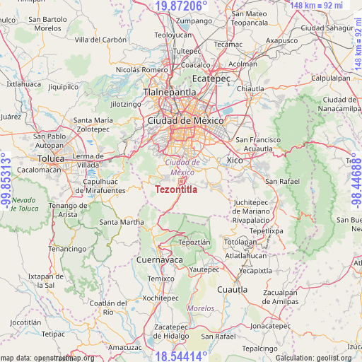
Tezontitla GPS coordinates[2]
19° 12' 33.984" North, 99° 9' 0" West
| Map corner | latitude | longitude |
|---|---|---|
| Upper-left | 19.87206°, | -99.85313° |
| Center: | 19.20944°, | -99.15° |
| Lower-right: | 18.54414°, | -98.44688° |
| Map W x H: | 147.7×147.7 km | = 91.8×91.8mi |
| max Lat: | 32.7° ⇑61% North |
| Tezontitla: | 19.20944° |
| min Lat: | ⇓39% South 14.53588° |
| min Long | Tezontitla | max Long |
| -117.105° | -99.15° | -86.73105° |
| W 48.1%⇐ | ⇒51.9% E |
Elevation
Elevation of Tezontitla is 2761 m = 9058 ft, and this is 1507.3 m = 4945 ft above average elevation for this country.
| Max E: |
3497 m = 11473 ft | 1.8% |
| Tezontitla | 2761 m 9058 ft | |
| Avg. | 1253.7 m = 4113 ft | |
Min E: |
-1 m = -3 ft | 98.2% |
See also: Mexico elevation on elevation.city.
Geographical zone
Tezontitla is located in North Torrid zone (between Equator and Tropic of Cancer). Distance of this Northern Tropic circle is 470 km =292 mi to North.| Distance of | km | miles | from Tezontitla |
|---|---|---|---|
| North Pole | 7871.2 | 4890.9 | to North |
| Arctic Circle | 5265.3 | 3271.7 | to North |
| Tropic Cancer | 470 | 292 | to North |
| Equator | 2135.9 | 1327.2 | to South |


Nearby cities:
15 places around Tezontitla: (largest is in red/bold)
• Coyoacán
15.3 km =9.5 mi,  355°
355°
• Lomas de Tepemecatl
9.9 km =6.2 mi,  289°
289°
• Magdalena Contreras
15.1 km =9.4 mi,  334°
334°
• Milpa Alta
13.5 km =8.4 mi,  98°
98°
• San Bartolome Xicomulco
8.6 km =5.3 mi,  92°
92°
• San Francisco Tecoxpa
15.2 km =9.4 mi, 97°
• San Isidro Cuatepec
15 km =9.3 mi, 85°
• San Lorenzo Tlacoyucan
12.9 km =8 mi,  106°
106°
• San Miguel Ajusco
5.7 km =3.5 mi,  284°
284°
• San Miguel Topilejo
1.1 km =0.7 mi,  131°
131°
• San Pablo Oztotepec
8.4 km =5.2 mi, 107°
• San Pedro Atocpan
10.6 km =6.6 mi, 94°
• San Salvador Cuauhtenco
6.6 km =4.1 mi, 106°
• Tlalpan
9.6 km =6 mi,  352°
352°
• Xochimilco
7 km =4.3 mi,  44°
44°
Sources, notices
• [Note1] Compared only with cities in Mexico existing in our database
• [Src1] Map data: © OpenStreetMap contributors (CC-BY-SA)
• [Src2] Other city data from geonames.org with taken over terms of usage.
• [Src3] Geographical zone / Annual Mean Temperature by Robert A. Rohde @ Wikipedia
