Tlalpan geodata
Tlalpan (Mexico City) is a populated place; located in Mexico in America/Mexico_City (GMT-6) time zone. With population of 574,577 people, there are 33 cities with bigger population in this country. Compared to other cities in Mexico, 58.9% of cities are located further ↑North; 52.1% of cities are located further →East and 84.8% of cities have lower elevation than Tlalpan. Note1


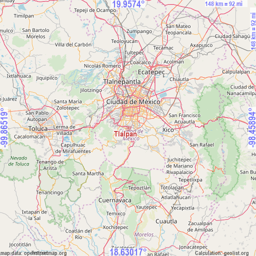
Tlalpan GPS coordinates[2]
19° 17' 42.468" North, 99° 9' 43.416" West
| Map corner | latitude | longitude |
|---|---|---|
| Upper-left | 19.9574°, | -99.86519° |
| Center: | 19.29513°, | -99.16206° |
| Lower-right: | 18.63017°, | -98.45894° |
| Map W x H: | 147.6×147.6 km | = 91.7×91.7mi |
| max Lat: | 32.7° ⇑58.9% North |
| Tlalpan: | 19.29513° |
| min Lat: | ⇓41.1% South 14.53588° |
| min Long | Tlalpan | max Long |
| -117.105° | -99.16206° | -86.73105° |
| W 47.9%⇐ | ⇒52.1% E |
Elevation
Elevation of Tlalpan is 2256 m = 7402 ft, and this is 1002.3 m = 3288 ft above average elevation for this country.
| Max E: |
3497 m = 11473 ft | 15.2% |
| Tlalpan | 2256 m 7402 ft | |
| Avg. | 1253.7 m = 4113 ft | |
Min E: |
-1 m = -3 ft | 84.8% |
See also: Tlalpan elevation on elevation.city.
Geographical zone
Tlalpan is located in North Torrid zone (between Equator and Tropic of Cancer). Distance of this Northern Tropic circle is 460.5 km =286.1 mi to North.| Distance of | km | miles | from Tlalpan |
|---|---|---|---|
| North Pole | 7861.6 | 4885 | to North |
| Arctic Circle | 5255.8 | 3265.8 | to North |
| Tropic Cancer | 460.5 | 286.1 | to North |
| Equator | 2145.4 | 1333.1 | to South |


Nearby cities:
15 places around Tlalpan: (largest is in red/bold)
• Benito Juarez
11.5 km =7.1 mi,  2°
2°
• Benito Juárez
8.6 km =5.3 mi, 3°
• Colonia Nativitas
9.9 km =6.2 mi,  15°
15°
• Colonia del Valle
10.1 km =6.3 mi, 0°
• Coyoacán
5.7 km =3.5 mi, 0°
• Iztacalco
13 km =8.1 mi,  31°
31°
• Iztapalapa
12.4 km =7.7 mi,  57°
57°
• Lomas de Tepemecatl
10.3 km =6.4 mi,  232°
232°
• Magdalena Contreras
6.6 km =4.1 mi,  308°
308°
• San Miguel Ajusco
9.2 km =5.7 mi,  207°
207°
• San Miguel Topilejo
10.5 km =6.5 mi,  168°
168°
• San Salvador Cuauhtenco
13.7 km =8.5 mi,  146°
146°
• Tezontitla
9.6 km =6 mi, 172°
• Xochimilco
7.6 km =4.7 mi,  126°
126°
• Álvaro Obregón
8.3 km =5.2 mi,  328°
328°
Sources, notices
• [Note1] Compared only with cities in Mexico existing in our database
• [Src1] Map data: © OpenStreetMap contributors (CC-BY-SA)
• [Src2] Other city data from geonames.org with taken over terms of usage.
• [Src3] Geographical zone / Annual Mean Temperature by Robert A. Rohde @ Wikipedia
