Lomas de Tepemecatl geodata
Lomas de Tepemecatl (Mexico City) is a populated place; located in Mexico in America/Mexico_City (GMT-6) time zone. With population of 1,392 people, there are 6215 cities with bigger population in this country. Compared to other cities in Mexico, 60.2% of cities are located further ↑North; 53.5% of cities are located further →East and 99.7% of cities have lower elevation than Lomas de Tepemecatl. Note1


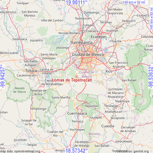
Lomas de Tepemecatl GPS coordinates[2]
19° 14' 18.996" North, 99° 14' 21.984" West
| Map corner | latitude | longitude |
|---|---|---|
| Upper-left | 19.90111°, | -99.94257° |
| Center: | 19.23861°, | -99.23944° |
| Lower-right: | 18.57342°, | -98.53632° |
| Map W x H: | 147.6×147.6 km | = 91.7×91.7mi |
| max Lat: | 32.7° ⇑60.2% North |
| Lomas de Tepemecatl: | 19.23861° |
| min Lat: | ⇓39.8% South 14.53588° |
| min Long | Lomas de Tepeme | max Long |
| -117.105° | -99.23944° | -86.73105° |
| W 46.5%⇐ | ⇒53.5% E |
Elevation
Elevation of Lomas de Tepemecatl is 2955 m = 9695 ft, and this is 1701.3 m = 5582 ft above average elevation for this country.
| Max E: |
3497 m = 11473 ft | 0.3% |
| Lomas de Tepemecatl | 2955 m 9695 ft | |
| Avg. | 1253.7 m = 4113 ft | |
Min E: |
-1 m = -3 ft | 99.7% |
See also: Mexico elevation on elevation.city.
Geographical zone
Lomas de Tepemecatl is located in North Torrid zone (between Equator and Tropic of Cancer). Distance of this Northern Tropic circle is 466.8 km =290.1 mi to North.| Distance of | km | miles | from Lomas de Tepemecatl |
|---|---|---|---|
| North Pole | 7867.9 | 4888.9 | to North |
| Arctic Circle | 5262 | 3269.7 | to North |
| Tropic Cancer | 466.8 | 290.1 | to North |
| Equator | 2139.1 | 1329.2 | to South |


Nearby cities:
15 places around Lomas de Tepemecatl: (largest is in red/bold)
• Colonia La Venta
13.1 km =8.1 mi,  324°
324°
• Coyoacán
14.5 km =9 mi,  34°
34°
• Cruz Blanca
12.5 km =7.8 mi, 315°
• Delegación Cuajimalpa de Morelos
15.5 km =9.6 mi,  339°
339°
• El Mirasol
15.7 km =9.8 mi, 321°
• La Marquesa
15.2 km =9.4 mi,  296°
296°
• Magdalena Contreras
10.8 km =6.7 mi,  15°
15°
• San Lorenzo Acopilco
13.7 km =8.5 mi, 317°
• San Miguel Ajusco
4.3 km =2.7 mi,  115°
115°
• San Miguel Topilejo
11 km =6.8 mi,  111°
111°
• Santa Rosa
11.1 km =6.9 mi,  327°
327°
• Tezontitla
9.9 km =6.2 mi, 109°
• Tlalpan
10.3 km =6.4 mi,  52°
52°
• Xochimilco
14.4 km =8.9 mi,  82°
82°
• Álvaro Obregón
13.9 km =8.6 mi, 15°
Sources, notices
• [Note1] Compared only with cities in Mexico existing in our database
• [Src1] Map data: © OpenStreetMap contributors (CC-BY-SA)
• [Src2] Other city data from geonames.org with taken over terms of usage.
• [Src3] Geographical zone / Annual Mean Temperature by Robert A. Rohde @ Wikipedia
