Almecatla geodata
Almecatla (Puebla) is a populated place; located in Mexico in America/Mexico_City (GMT-6) time zone. With population of 13,217 people, there are 743 cities with bigger population in this country. Compared to other cities in Mexico, 62.3% of cities are located further ↑North; 60.7% of cities are located further ←West and 83.2% of cities have lower elevation than Almecatla. Note1


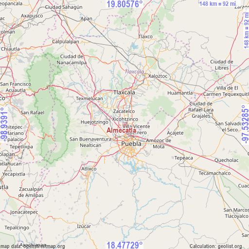
Almecatla GPS coordinates[2]
19° 8' 34.296" North, 98° 14' 9.492" West
| Map corner | latitude | longitude |
|---|---|---|
| Upper-left | 19.80576°, | -98.9391° |
| Center: | 19.14286°, | -98.23597° |
| Lower-right: | 18.47729°, | -97.53285° |
| Map W x H: | 147.7×147.7 km | = 91.8×91.8mi |
| max Lat: | 32.7° ⇑62.3% North |
| Almecatla: | 19.14286° |
| min Lat: | ⇓37.7% South 14.53588° |
| min Long | Almecatla | max Long |
| -117.105° | -98.23597° | -86.73105° |
| W 60.7%⇐ | ⇒39.3% E |
Elevation
Elevation of Almecatla is 2224 m = 7297 ft, and this is 970.3 m = 3183 ft above average elevation for this country.
| Max E: |
3497 m = 11473 ft | 16.8% |
| Almecatla | 2224 m 7297 ft | |
| Avg. | 1253.7 m = 4113 ft | |
Min E: |
-1 m = -3 ft | 83.2% |
See also: Mexico elevation on elevation.city.
Geographical zone
Almecatla is located in North Torrid zone (between Equator and Tropic of Cancer). Distance of this Northern Tropic circle is 477.4 km =296.6 mi to North.| Distance of | km | miles | from Almecatla |
|---|---|---|---|
| North Pole | 7878.6 | 4895.5 | to North |
| Arctic Circle | 5272.7 | 3276.3 | to North |
| Tropic Cancer | 477.4 | 296.6 | to North |
| Equator | 2128.5 | 1322.6 | to South |


Nearby cities:
15 places around Almecatla: (largest is in red/bold)
• Coronango
7.7 km =4.8 mi,  251°
251°
• Cuautlancingo
7.1 km =4.4 mi,  213°
213°
• La Trinidad Chautenco
6.6 km =4.1 mi, 206°
• Mazatecochco
6.5 km =4 mi,  52°
52°
• Papalotla
4.4 km =2.7 mi, 49°
• San Antonio Mihuacán
7.3 km =4.5 mi,  279°
279°
• San Francisco Ocotlán
5.1 km =3.2 mi,  258°
258°
• San Jacinto
1.8 km =1.1 mi,  311°
311°
• San Marcos Contla
7.3 km =4.5 mi,  31°
31°
• San Miguel Xoxtla
8 km =5 mi,  290°
290°
• Sanctorum
5.2 km =3.2 mi,  201°
201°
• Santa Catarina Ayometla
6.6 km =4.1 mi,  20°
20°
• Tenancingo
3.7 km =2.3 mi,  82°
82°
• Villa Vicente Guerrero
7.8 km =4.8 mi,  108°
108°
• Xicohtzinco
3.4 km =2.1 mi,  3°
3°
Sources, notices
• [Note1] Compared only with cities in Mexico existing in our database
• [Src1] Map data: © OpenStreetMap contributors (CC-BY-SA)
• [Src2] Other city data from geonames.org with taken over terms of usage.
• [Src3] Geographical zone / Annual Mean Temperature by Robert A. Rohde @ Wikipedia
