Tecuanipan geodata
Tecuanipan (Puebla) is a populated place; located in Mexico in America/Mexico_City (GMT-6) time zone. With population of 2,179 people, there are 4034 cities with bigger population in this country. Compared to other cities in Mexico, 64.5% of cities are located further ↑North; 58.6% of cities are located further ←West and 80.8% of cities have lower elevation than Tecuanipan. Note1


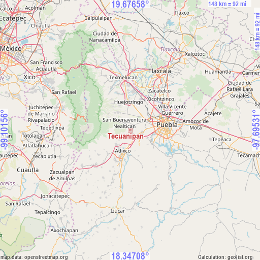
Tecuanipan GPS coordinates[2]
19° 0' 47.376" North, 98° 23' 54.348" West
| Map corner | latitude | longitude |
|---|---|---|
| Upper-left | 19.67658°, | -99.10156° |
| Center: | 19.01316°, | -98.39843° |
| Lower-right: | 18.34708°, | -97.69531° |
| Map W x H: | 147.8×147.8 km | = 91.8×91.8mi |
| max Lat: | 32.7° ⇑64.5% North |
| Tecuanipan: | 19.01316° |
| min Lat: | ⇓35.5% South 14.53588° |
| min Long | Tecuanipan | max Long |
| -117.105° | -98.39843° | -86.73105° |
| W 58.6%⇐ | ⇒41.4% E |
Elevation
Elevation of Tecuanipan is 2159 m = 7083 ft, and this is 905.3 m = 2970 ft above average elevation for this country.
| Max E: |
3497 m = 11473 ft | 19.2% |
| Tecuanipan | 2159 m 7083 ft | |
| Avg. | 1253.7 m = 4113 ft | |
Min E: |
-1 m = -3 ft | 80.8% |
See also: Mexico elevation on elevation.city.
Geographical zone
Tecuanipan is located in North Torrid zone (between Equator and Tropic of Cancer). Distance of this Northern Tropic circle is 491.9 km =305.7 mi to North.| Distance of | km | miles | from Tecuanipan |
|---|---|---|---|
| North Pole | 7893 | 4904.5 | to North |
| Arctic Circle | 5287.1 | 3285.3 | to North |
| Tropic Cancer | 491.9 | 305.7 | to North |
| Equator | 2114.1 | 1313.6 | to South |


Nearby cities:
15 places around Tecuanipan: (largest is in red/bold)
• Acuexcomac
3 km =1.9 mi,  27°
27°
• Chipilo de Francisco Javier Mina
7.2 km =4.5 mi,  96°
96°
• Los Reyes Tlanechicolpan
5.3 km =3.3 mi,  65°
65°
• Nealtican
5.1 km =3.2 mi,  323°
323°
• San Bernabé Temoxtitla
7.3 km =4.5 mi, 104°
• San Francisco Cuapa
7 km =4.3 mi, 29°
• San Gregorio Atzompa
5.4 km =3.4 mi,  77°
77°
• San Luis Tehuiloyocan
7 km =4.3 mi, 65°
• San Martín Tlamapa
4 km =2.5 mi,  177°
177°
• San Miguel Papaxtla
5.6 km =3.5 mi,  9°
9°
• San Pablo Ahuatempa
5.5 km =3.4 mi,  130°
130°
• Santa Ana Acozautla
6.6 km =4.1 mi,  165°
165°
• Santa Isabel Cholula
2.7 km =1.7 mi, 132°
• Tianguismanalco
6.7 km =4.2 mi,  232°
232°
• Zacapechpan
6.8 km =4.2 mi,  47°
47°
Sources, notices
• [Note1] Compared only with cities in Mexico existing in our database
• [Src1] Map data: © OpenStreetMap contributors (CC-BY-SA)
• [Src2] Other city data from geonames.org with taken over terms of usage.
• [Src3] Geographical zone / Annual Mean Temperature by Robert A. Rohde @ Wikipedia
