San Miguel Papaxtla geodata
San Miguel Papaxtla (Puebla) is a populated place; located in Mexico in America/Mexico_City (GMT-6) time zone. With population of 1,526 people, there are 5654 cities with bigger population in this country. Compared to other cities in Mexico, 63.7% of cities are located further ↑North; 58.8% of cities are located further ←West and 83.8% of cities have lower elevation than San Miguel Papaxtla. Note1


San Miguel Papaxtla GPS coordinates[2]
19° 3' 46.008" North, 98° 23' 24" West
| Map corner | latitude | longitude |
|---|---|---|
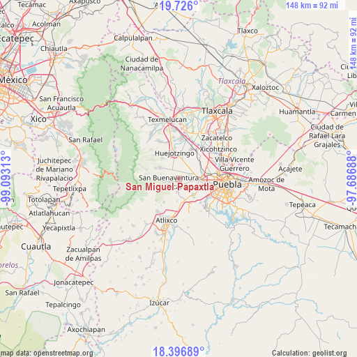
| Upper-left | 19.726°, | -99.09313° |
| Center: | 19.06278°, | -98.39° |
| Lower-right: | 18.39689°, | -97.68688° |
| Map W x H: | 147.8×147.8 km | = 91.8×91.8mi |
| max Lat: | 32.7° ⇑63.7% North |
| San Miguel Papaxtla: | 19.06278° |
| min Lat: | ⇓36.3% South 14.53588° |
| min Long | San Miguel Papa | max Long |
| -117.105° | -98.39° | -86.73105° |
| W 58.8%⇐ | ⇒41.2% E |
Elevation
Elevation of San Miguel Papaxtla is 2238 m = 7343 ft, and this is 984.3 m = 3229 ft above average elevation for this country.
| Max E: |
3497 m = 11473 ft | 16.2% |
| San Miguel Papaxtla | 2238 m 7343 ft | |
| Avg. | 1253.7 m = 4113 ft | |
Min E: |
-1 m = -3 ft | 83.8% |
See also: Mexico elevation on elevation.city.
Geographical zone
San Miguel Papaxtla is located in North Torrid zone (between Equator and Tropic of Cancer). Distance of this Northern Tropic circle is 486.3 km =302.2 mi to North.| Distance of | km | miles | from San Miguel Papaxtla |
|---|---|---|---|
| North Pole | 7887.5 | 4901.1 | to North |
| Arctic Circle | 5281.6 | 3281.8 | to North |
| Tropic Cancer | 486.3 | 302.2 | to North |
| Equator | 2119.6 | 1317.1 | to South |


Nearby cities:
15 places around San Miguel Papaxtla: (largest is in red/bold)
• Acuexcomac
2.9 km =1.8 mi,  169°
169°
• Chipilo de Francisco Javier Mina
8.9 km =5.5 mi,  135°
135°
• Cháhuac
7.5 km =4.7 mi,  330°
330°
• Cuanalá
8.3 km =5.2 mi,  51°
51°
• Los Reyes Tlanechicolpan
5.2 km =3.2 mi,  130°
130°
• Nealtican
4.2 km =2.6 mi,  249°
249°
• Pueblo Nuevo
7.1 km =4.4 mi,  312°
312°
• San Andrés Calpan
8.8 km =5.5 mi,  300°
300°
• San Francisco Cuapa
2.6 km =1.6 mi,  76°
76°
• San Gregorio Atzompa
6.2 km =3.9 mi, 134°
• San Luis Tehuiloyocan
6.1 km =3.8 mi,  115°
115°
• Santa Isabel Cholula
7.4 km =4.6 mi, 171°
• Santa María Zacatepec
7.2 km =4.5 mi,  21°
21°
• Tecuanipan
5.6 km =3.5 mi,  189°
189°
• Zacapechpan
4.2 km =2.6 mi,  102°
102°
Sources, notices
• [Note1] Compared only with cities in Mexico existing in our database
• [Src1] Map data: © OpenStreetMap contributors (CC-BY-SA)
• [Src2] Other city data from geonames.org with taken over terms of usage.
• [Src3] Geographical zone / Annual Mean Temperature by Robert A. Rohde @ Wikipedia
