Acuexcomac geodata
Acuexcomac (Puebla) is a populated place; located in Mexico in America/Mexico_City (GMT-6) time zone. With population of 4,432 people, there are 2074 cities with bigger population in this country. Compared to other cities in Mexico, 64.1% of cities are located further ↑North; 58.8% of cities are located further ←West and 81% of cities have lower elevation than Acuexcomac. Note1


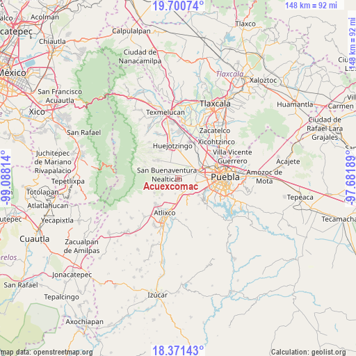
Acuexcomac GPS coordinates[2]
19° 2' 14.712" North, 98° 23' 6.036" West
| Map corner | latitude | longitude |
|---|---|---|
| Upper-left | 19.70074°, | -99.08814° |
| Center: | 19.03742°, | -98.38501° |
| Lower-right: | 18.37143°, | -97.68189° |
| Map W x H: | 147.8×147.8 km | = 91.8×91.8mi |
| max Lat: | 32.7° ⇑64.1% North |
| Acuexcomac: | 19.03742° |
| min Lat: | ⇓35.9% South 14.53588° |
| min Long | Acuexcomac | max Long |
| -117.105° | -98.38501° | -86.73105° |
| W 58.8%⇐ | ⇒41.2% E |
Elevation
Elevation of Acuexcomac is 2164 m = 7100 ft, and this is 910.3 m = 2987 ft above average elevation for this country.
| Max E: |
3497 m = 11473 ft | 19% |
| Acuexcomac | 2164 m 7100 ft | |
| Avg. | 1253.7 m = 4113 ft | |
Min E: |
-1 m = -3 ft | 81% |
See also: Mexico elevation on elevation.city.
Geographical zone
Acuexcomac is located in North Torrid zone (between Equator and Tropic of Cancer). Distance of this Northern Tropic circle is 489.2 km =304 mi to North.| Distance of | km | miles | from Acuexcomac |
|---|---|---|---|
| North Pole | 7890.3 | 4902.8 | to North |
| Arctic Circle | 5284.4 | 3283.6 | to North |
| Tropic Cancer | 489.2 | 304 | to North |
| Equator | 2116.8 | 1315.3 | to South |


Nearby cities:
15 places around Acuexcomac: (largest is in red/bold)
• Chalchihuapan
8.9 km =5.5 mi,  145°
145°
• Chipilo de Francisco Javier Mina
6.7 km =4.2 mi,  121°
121°
• Los Reyes Tlanechicolpan
3.5 km =2.2 mi,  99°
99°
• Nealtican
4.6 km =2.9 mi,  287°
287°
• San Bernabé Temoxtitla
7.2 km =4.5 mi,  128°
128°
• San Francisco Cuapa
4 km =2.5 mi,  30°
30°
• San Gregorio Atzompa
4.2 km =2.6 mi,  111°
111°
• San Luis Tehuiloyocan
5 km =3.1 mi,  87°
87°
• San Martín Tlamapa
6.8 km =4.2 mi,  190°
190°
• San Miguel Papaxtla
2.9 km =1.8 mi,  349°
349°
• San Pablo Ahuatempa
6.8 km =4.2 mi,  156°
156°
• Santa Isabel Cholula
4.6 km =2.9 mi,  172°
172°
• Santa Martha Hidalgo
8.6 km =5.3 mi, 132°
• Tecuanipan
3 km =1.9 mi,  207°
207°
• Zacapechpan
4 km =2.5 mi,  62°
62°
Sources, notices
• [Note1] Compared only with cities in Mexico existing in our database
• [Src1] Map data: © OpenStreetMap contributors (CC-BY-SA)
• [Src2] Other city data from geonames.org with taken over terms of usage.
• [Src3] Geographical zone / Annual Mean Temperature by Robert A. Rohde @ Wikipedia
