Nealtican geodata
Nealtican (Puebla) is a seat of a second-order administrative division; located in Mexico in America/Mexico_City (GMT-6) time zone. With population of 11,517 people, there are 834 cities with bigger population in this country. Compared to other cities in Mexico, 63.9% of cities are located further ↑North; 58.3% of cities are located further ←West and 83.7% of cities have lower elevation than Nealtican. Note1


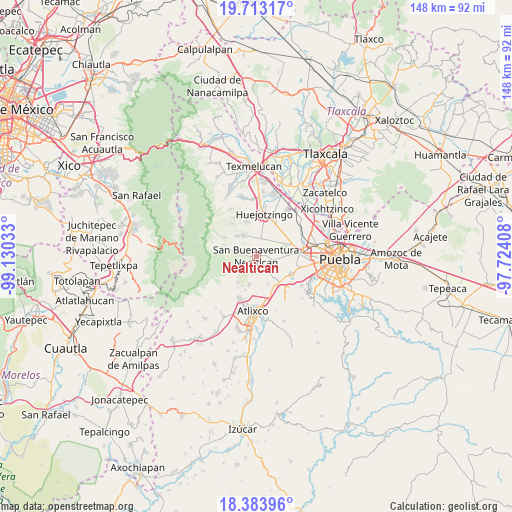
Nealtican GPS coordinates[2]
19° 2' 59.64" North, 98° 25' 37.92" West
| Map corner | latitude | longitude |
|---|---|---|
| Upper-left | 19.71317°, | -99.13033° |
| Center: | 19.0499°, | -98.4272° |
| Lower-right: | 18.38396°, | -97.72408° |
| Map W x H: | 147.8×147.8 km | = 91.8×91.8mi |
| max Lat: | 32.7° ⇑63.9% North |
| Nealtican: | 19.0499° |
| min Lat: | ⇓36.1% South 14.53588° |
| min Long | Nealtican | max Long |
| -117.105° | -98.4272° | -86.73105° |
| W 58.3%⇐ | ⇒41.7% E |
Elevation
Elevation of Nealtican is 2236 m = 7336 ft, and this is 982.3 m = 3223 ft above average elevation for this country.
| Max E: |
3497 m = 11473 ft | 16.3% |
| Nealtican | 2236 m 7336 ft | |
| Avg. | 1253.7 m = 4113 ft | |
Min E: |
-1 m = -3 ft | 83.7% |
See also: Mexico elevation on elevation.city.
Geographical zone
Nealtican is located in North Torrid zone (between Equator and Tropic of Cancer). Distance of this Northern Tropic circle is 487.8 km =303.1 mi to North.| Distance of | km | miles | from Nealtican |
|---|---|---|---|
| North Pole | 7888.9 | 4901.9 | to North |
| Arctic Circle | 5283 | 3282.7 | to North |
| Tropic Cancer | 487.8 | 303.1 | to North |
| Equator | 2118.2 | 1316.2 | to South |


Nearby cities:
15 places around Nealtican: (largest is in red/bold)
• Acuexcomac
4.6 km =2.9 mi,  107°
107°
• Cháhuac
8 km =5 mi,  1°
1°
• Los Reyes Tlanechicolpan
8.1 km =5 mi,  103°
103°
• Pueblo Nuevo
6.4 km =4 mi,  348°
348°
• San Andrés Calpan
7 km =4.3 mi,  328°
328°
• San Francisco Cuapa
6.8 km =4.2 mi,  72°
72°
• San Lucas Atzala
8.3 km =5.2 mi,  316°
316°
• San Martín Tlamapa
8.7 km =5.4 mi,  158°
158°
• San Miguel Papaxtla
4.2 km =2.6 mi, 69°
• San Nicolás de los Ranchos
6.6 km =4.1 mi,  291°
291°
• San Pedro Yancuitlalpan
6.6 km =4.1 mi,  297°
297°
• Santa Isabel Cholula
7.8 km =4.8 mi,  139°
139°
• Tecuanipan
5.1 km =3.2 mi, 143°
• Tianguismanalco
8.5 km =5.3 mi,  195°
195°
• Zacapechpan
8 km =5 mi,  86°
86°
Sources, notices
• [Note1] Compared only with cities in Mexico existing in our database
• [Src1] Map data: © OpenStreetMap contributors (CC-BY-SA)
• [Src2] Other city data from geonames.org with taken over terms of usage.
• [Src3] Geographical zone / Annual Mean Temperature by Robert A. Rohde @ Wikipedia
