San Jerónimo Taviche geodata
San Jerónimo Taviche (Oaxaca) is a seat of a second-order administrative division; located in Mexico in America/Mexico_City (GMT-6) time zone. With population of 1,688 people, there are 5145 cities with bigger population in this country. Compared to other cities in Mexico, 92.7% of cities are located further ↑North; 79.2% of cities are located further ←West and 58.7% of cities have lower elevation than San Jerónimo Taviche. Note1


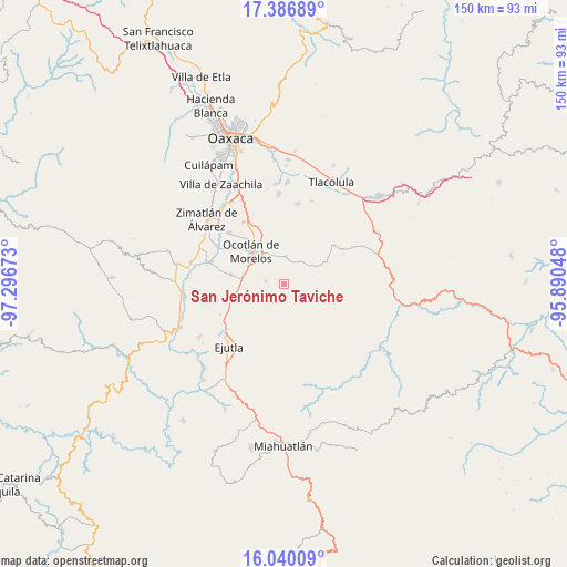
San Jerónimo Taviche GPS coordinates[2]
16° 42' 52.848" North, 96° 35' 36.96" West
| Map corner | latitude | longitude |
|---|---|---|
| Upper-left | 17.38689°, | -97.29673° |
| Center: | 16.71468°, | -96.5936° |
| Lower-right: | 16.04009°, | -95.89048° |
| Map W x H: | 149.8×149.8 km | = 93.1×93.1mi |
| max Lat: | 32.7° ⇑92.7% North |
| San Jerónimo Taviche: | 16.71468° |
| min Lat: | ⇓7.3% South 14.53588° |
| min Long | San Jerónimo T | max Long |
| -117.105° | -96.5936° | -86.73105° |
| W 79.2%⇐ | ⇒20.8% E |
Elevation
Elevation of San Jerónimo Taviche is 1703 m = 5587 ft, and this is 449.3 m = 1474 ft above average elevation for this country.
| Max E: |
3497 m = 11473 ft | 41.3% |
| San Jerónimo Taviche | 1703 m 5587 ft | |
| Avg. | 1253.7 m = 4113 ft | |
Min E: |
-1 m = -3 ft | 58.7% |
See also: Mexico elevation on elevation.city.
Geographical zone
San Jerónimo Taviche is located in North Torrid zone (between Equator and Tropic of Cancer). Distance of this Northern Tropic circle is 747.4 km =464.4 mi to North.| Distance of | km | miles | from San Jerónimo Taviche |
|---|---|---|---|
| North Pole | 8148.6 | 5063.3 | to North |
| Arctic Circle | 5542.7 | 3444.1 | to North |
| Tropic Cancer | 747.4 | 464.4 | to North |
| Equator | 1858.5 | 1154.8 | to South |


Nearby cities:
15 places around San Jerónimo Taviche: (largest is in red/bold)
• Magdalena Ocotlán
12.4 km =7.7 mi,  266°
266°
• Maguey Largo
7.5 km =4.7 mi,  242°
242°
• Ocotlán de Morelos
12.1 km =7.5 mi,  314°
314°
• Praxedis de Guerrero
5 km =3.1 mi,  276°
276°
• San Antonino Castillo Velasco
13.5 km =8.4 mi,  315°
315°
• San Baltazar Chichicapam
12.2 km =7.6 mi,  64°
64°
• San Dionisio Ocotlán
9.9 km =6.2 mi,  291°
291°
• San José del Progreso
10.2 km =6.3 mi,  252°
252°
• San José la Garzona
6.1 km =3.8 mi,  231°
231°
• San Miguel Tilquiapam
7.6 km =4.7 mi,  9°
9°
• San Pedro Martir
12.9 km =8 mi, 284°
• San Pedro Taviche
10.4 km =6.5 mi,  144°
144°
• Santa Catarina Minas
7.6 km =4.7 mi,  342°
342°
• Santa Lucía Ocotlán
9.5 km =5.9 mi, 286°
• Yaxe
13 km =8.1 mi,  84°
84°
Sources, notices
• [Note1] Compared only with cities in Mexico existing in our database
• [Src1] Map data: © OpenStreetMap contributors (CC-BY-SA)
• [Src2] Other city data from geonames.org with taken over terms of usage.
• [Src3] Geographical zone / Annual Mean Temperature by Robert A. Rohde @ Wikipedia
