San Francisco Manzanilla geodata
San Francisco Manzanilla (Yucatán) is a populated place; located in Mexico in America/Merida (GMT-6) time zone. With population of 669 people, there are 12968 cities with bigger population in this country. Compared to other cities in Mexico, 79.6% of cities are located further ↓South; 98.7% of cities are located further ←West and 98.7% of cities have higher elevation than San Francisco Manzanilla. Note1
Current local time in San Francisco Manzanilla:
07:20 AM, MondayDifference from your time zone: hours


San Francisco Manzanilla GPS coordinates[2]
21° 15' 8.712" North, 89° 1' 22.872" West
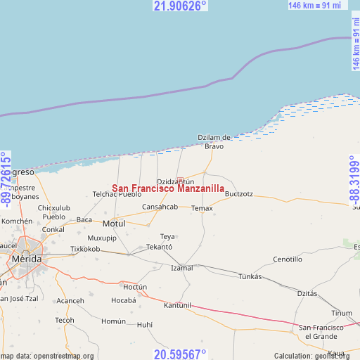
| Map corner | latitude | longitude |
|---|---|---|
| Upper-left | 21.90626°, | -89.72615° |
| Center: | 21.25242°, | -89.02302° |
| Lower-right: | 20.59567°, | -88.3199° |
| Map W x H: | 145.7×145.7 km | = 90.5×90.5mi |
| max Lat: | 32.7° ⇑20.4% North |
| San Francisco Manzanilla: | 21.25242° |
| min Lat: | ⇓79.6% South 14.53588° |
| min Long | San Francisco M | max Long |
| -117.105° | -89.02302° | -86.73105° |
| W 98.7%⇐ | ⇒1.3% E |
Elevation
Elevation of San Francisco Manzanilla is 7 m = 23 ft, and this is 1246.7 m = 4090 ft below average elevation for this country.
| Max E: |
3497 m = 11473 ft | 98.7% |
| Avg. | 1253.7 m = 4113 ft | |
| San Francisco Manzanilla | 7 m = 23 ft | |
Min E: |
-1 m = -3 ft | 1.3% |
See also: Mexico elevation on elevation.city.
Geographical zone
San Francisco Manzanilla is located in North Torrid zone (between Equator and Tropic of Cancer). Distance of this Northern Tropic circle is 242.9 km =150.9 mi to North.| Distance of | km | miles | from San Francisco Manzanilla |
|---|---|---|---|
| North Pole | 7644 | 4749.8 | to North |
| Arctic Circle | 5038.1 | 3130.5 | to North |
| Tropic Cancer | 242.9 | 150.9 | to North |
| Equator | 2363 | 1468.3 | to South |


Nearby cities:
15 places around San Francisco Manzanilla: (largest is in red/bold)
• Buctzotz
24.5 km =15.2 mi,  102°
102°
• Cansahcab
13.3 km =8.3 mi,  217°
217°
• Dzidzantun
2 km =1.2 mi,  259°
259°
• Dzilam González
10.2 km =6.3 mi,  71°
71°
• Dzilam de Bravo
20.5 km =12.7 mi,  40°
40°
• Dzoncauich
19.4 km =12.1 mi,  134°
134°
• San Crisanto
19.3 km =12 mi,  305°
305°
• San Pedro Chacabal
21.9 km =13.6 mi,  233°
233°
• Sinanche
17 km =10.6 mi, 260°
• Suma de Hidalgo
22.5 km =14 mi, 215°
• Telchac Pueblo
26.1 km =16.2 mi, 257°
• Temax
14.2 km =8.8 mi,  142°
142°
• Tepakan
22.7 km =14.1 mi,  184°
184°
• Teya
23 km =14.3 mi,  193°
193°
• Yobain
9.7 km =6 mi, 258°
Sources, notices
• [Note1] Compared only with cities in Mexico existing in our database
• [Src1] Map data: © OpenStreetMap contributors (CC-BY-SA)
• [Src2] Other city data from geonames.org with taken over terms of usage.
• [Src3] Geographical zone / Annual Mean Temperature by Robert A. Rohde @ Wikipedia
