Dzoncauich geodata
Dzoncauich (Yucatán) is a populated place; located in Mexico in America/Merida (GMT-6) time zone. With population of 2,318 people, there are 3808 cities with bigger population in this country. Compared to other cities in Mexico, 78.3% of cities are located further ↓South; 98.9% of cities are located further ←West and 96.3% of cities have higher elevation than Dzoncauich. Note1


Dzoncauich GPS coordinates[2]
21° 7' 45.768" North, 88° 53' 23.1" West
| Map corner | latitude | longitude |
|---|---|---|
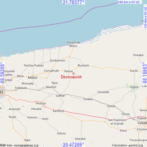
| Upper-left | 21.78377°, | -89.59288° |
| Center: | 21.12938°, | -88.88975° |
| Lower-right: | 20.47209°, | -88.18663° |
| Map W x H: | 145.8×145.8 km | = 90.6×90.6mi |
| max Lat: | 32.7° ⇑21.7% North |
| Dzoncauich: | 21.12938° |
| min Lat: | ⇓78.3% South 14.53588° |
| min Long | Dzoncauich | max Long |
| -117.105° | -88.88975° | -86.73105° |
| W 98.9%⇐ | ⇒1.1% E |
Elevation
Elevation of Dzoncauich is 11 m = 36 ft, and this is 1242.7 m = 4077 ft below average elevation for this country.
| Max E: |
3497 m = 11473 ft | 96.3% |
| Avg. | 1253.7 m = 4113 ft | |
| Dzoncauich | 11 m = 36 ft | |
Min E: |
-1 m = -3 ft | 3.7% |
See also: Mexico elevation on elevation.city.
Geographical zone
Dzoncauich is located in North Torrid zone (between Equator and Tropic of Cancer). Distance of this Northern Tropic circle is 256.6 km =159.4 mi to North.| Distance of | km | miles | from Dzoncauich |
|---|---|---|---|
| North Pole | 7657.7 | 4758.3 | to North |
| Arctic Circle | 5051.8 | 3139 | to North |
| Tropic Cancer | 256.6 | 159.4 | to North |
| Equator | 2349.4 | 1459.8 | to South |


Nearby cities:
15 places around Dzoncauich: (largest is in red/bold)
• Buctzotz
13 km =8.1 mi,  50°
50°
• Cansahcab
22.2 km =13.8 mi,  278°
278°
• Dzidzantun
20.6 km =12.8 mi,  310°
310°
• Dzilam González
17.4 km =10.8 mi,  346°
346°
• Izamal
25.3 km =15.7 mi,  211°
211°
• San Francisco Manzanilla
19.4 km =12.1 mi, 314°
• Sitilpech
22.1 km =13.7 mi,  198°
198°
• Suma de Hidalgo
27.2 km =16.9 mi,  259°
259°
• Tekal de Venegas
14 km =8.7 mi, 204°
• Tekanto
26.2 km =16.3 mi,  239°
239°
• Temax
5.8 km =3.6 mi,  294°
294°
• Tepakan
17.9 km =11.1 mi, 239°
• Teya
20.9 km =13 mi,  245°
245°
• Tunkas
29 km =18 mi,  150°
150°
• Yobain
26.1 km =16.2 mi,  296°
296°
Sources, notices
• [Note1] Compared only with cities in Mexico existing in our database
• [Src1] Map data: © OpenStreetMap contributors (CC-BY-SA)
• [Src2] Other city data from geonames.org with taken over terms of usage.
• [Src3] Geographical zone / Annual Mean Temperature by Robert A. Rohde @ Wikipedia
