Dzidzantun geodata
Dzidzantun (Yucatán) is a populated place; located in Mexico in America/Merida (GMT-6) time zone. With population of 7,393 people, there are 1256 cities with bigger population in this country. Compared to other cities in Mexico, 79.6% of cities are located further ↓South; 98.7% of cities are located further ←West and 97% of cities have higher elevation than Dzidzantun. Note1


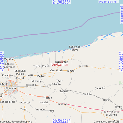
Dzidzantun GPS coordinates[2]
21° 14' 56.328" North, 89° 2' 31.38" West
| Map corner | latitude | longitude |
|---|---|---|
| Upper-left | 21.90283°, | -89.74518° |
| Center: | 21.24898°, | -89.04205° |
| Lower-right: | 20.59221°, | -88.33893° |
| Map W x H: | 145.7×145.7 km | = 90.5×90.5mi |
| max Lat: | 32.7° ⇑20.4% North |
| Dzidzantun: | 21.24898° |
| min Lat: | ⇓79.6% South 14.53588° |
| min Long | Dzidzantun | max Long |
| -117.105° | -89.04205° | -86.73105° |
| W 98.7%⇐ | ⇒1.3% E |
Elevation
Elevation of Dzidzantun is 10 m = 33 ft, and this is 1243.7 m = 4080 ft below average elevation for this country.
| Max E: |
3497 m = 11473 ft | 97% |
| Avg. | 1253.7 m = 4113 ft | |
| Dzidzantun | 10 m = 33 ft | |
Min E: |
-1 m = -3 ft | 3% |
See also: Mexico elevation on elevation.city.
Geographical zone
Dzidzantun is located in North Torrid zone (between Equator and Tropic of Cancer). Distance of this Northern Tropic circle is 243.3 km =151.2 mi to North.| Distance of | km | miles | from Dzidzantun |
|---|---|---|---|
| North Pole | 7644.4 | 4750 | to North |
| Arctic Circle | 5038.5 | 3130.8 | to North |
| Tropic Cancer | 243.3 | 151.2 | to North |
| Equator | 2362.7 | 1468.1 | to South |


Nearby cities:
15 places around Dzidzantun: (largest is in red/bold)
• Cansahcab
11.9 km =7.4 mi,  211°
211°
• Dzilam González
12.2 km =7.6 mi,  73°
73°
• Dzilam de Bravo
22.1 km =13.7 mi,  43°
43°
• Dzoncauich
20.6 km =12.8 mi,  130°
130°
• San Crisanto
18 km =11.2 mi,  310°
310°
• San Francisco Manzanilla
2 km =1.2 mi,  79°
79°
• San Pedro Chacabal
20.1 km =12.5 mi,  230°
230°
• Sinanche
15 km =9.3 mi,  260°
260°
• Suma de Hidalgo
21.1 km =13.1 mi, 211°
• Telchac Pueblo
24.1 km =15 mi, 257°
• Telchac Puerto
25.1 km =15.6 mi,  294°
294°
• Temax
15.2 km =9.4 mi,  135°
135°
• Tepakan
22.3 km =13.9 mi,  179°
179°
• Teya
22.3 km =13.9 mi,  188°
188°
• Yobain
7.7 km =4.8 mi, 257°
Sources, notices
• [Note1] Compared only with cities in Mexico existing in our database
• [Src1] Map data: © OpenStreetMap contributors (CC-BY-SA)
• [Src2] Other city data from geonames.org with taken over terms of usage.
• [Src3] Geographical zone / Annual Mean Temperature by Robert A. Rohde @ Wikipedia
